Overview for Penny Street, STURMINSTER NEWTON, DT10 1DE
Introduction
Sturminster Newton is a town and civil parish in the Blackmore Vale area of Dorset, England. It is situated on a low limestone ridge in a meander of the River Stour. The town is at the centre of a large dairy agriculture region, around which the town's economy is built. The larger part of the town (Sturminster) lies on the north side of the river, and includes most shops and services, whilst to the south is the smaller Newton. Between these two areas is a wide flood plain. The town was the home of poet and author William Barnes, and, for part of his life, Thomas Hardy. The town has 43 shops, a primary and secondary school, and a school and college catering for children with Special educational needs. In the 2011 census the town's civil parish had a population of 5,234.
A market is held in the town on Mondays. One of the largest cattle markets in England used to be held here, but it was closed in 1998 and now in its place stands a housing estate and a 300-seat community arts centre called The Exchange. The town is part of the historic West Country Carnival circuit. The town also has the nickname of 'the heart of the Blackmore vale' due to its central location within that area.
Summary for Penny Street, STURMINSTER NEWTON, DT10 1DE
Roadworks near DT10 1DE
Road Safety near DT10 1DE
Details of personal injury accidents in and around Penny Street, DT10 1DE that have been reported to Dorset Police over the past 20 years.
Traffic Levels near DT10 1DE
View traffic levels near Penny Street, DT10 1DE from official Department for Transport counts.
Images taken near to Penny Street, DT10 1DE and the surrounding area
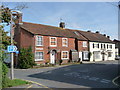
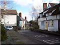
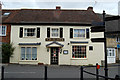

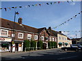


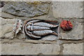

Please click the More button for more images, licensing and image copyright information.
Police
This area is policed by Dorset Police.
Dorset Police split their policing area into 21 separate neighbourhoods and this postcode is in the North Dorset Rural neighbourhood.

North Dorset Rural Neighbourhood Crime
Top 3 Categories
For full details of all categories together with more crime information, click on the Details button.
Member of UK Parliament
This postcode is in the North Dorset parliamentary constituency.
North Dorset is a constituency in the South West region of England. The seat has been held by Simon Hoare (Conservative) since May 2015.

Most Recent House Sales for Penny Street, DT10 1DE
29 Jul 2022
22 Oct 2021
22 Oct 2021
2 Mar 2021
Local Petrol Station Prices
Coordinates for DT10 1DE
Residents at DT10 1DE
Sunrise and Sunset at DT10 1DE
Traffic Emission and Congestion Zones
Historical Weather Summary
| Clear | 22.36% |
| Cloudy | 63.49% |
| Rain | 7.83% |
| Windy | 6.15% |
| Other | 0.17% |
Deprivation Index
the more deprived the postcode
Average Energy Performance
Companies Registered at DT10 1DE
Postcode Details for DT10 1DE
Recent Updates
|
18 Apr 2024 Added Traffic Camera Views from Traffic Scotland to Roadworks within Scotland |
|
15 Apr 2024 Schools Data updated for April 2024 |
|
10 Apr 2024 Companies Data updated for March 2024 |
|
7 Apr 2024 New option to receive automatic updates to roadworks that affect you |
|
7 Apr 2024 Police and Crime data updated for February 2024 |
|
3 Apr 2024 Sold House Price data updated for February 2024 |
|
30 Mar 2024 Energy Performance Certificates (England and Wales) updated February 2024 |
|
28 Mar 2024 New feature to use Geolocating functions to detect your current location |
Random Postcodes
Want an idea of what is in our extensive website? Try somewhere completely random!
The Rural/Urban classification is based upon data collected during the 2011 Census and released in August 2013 and is categorised into 6 distinct classes.
[A] Urban Major conurbation: A built up area with a population of 10,000 (3,000 in Scotland) or more and is assigned to the major conurbation settlement category.
[B] Urban Minor conurbation: A built up area with a population of 10,000 (3,000 in Scotland) or more and is assigned to the minor conurbation settlement category.
[C] Urban City and town: A built up area with a population of 10,000 (3,000 in Scotland) or more and is assigned to the city and town settlement category.
[D] Rural Town and fringe
[E] Rural Village
[F] Rural Hamlet and isolated dwelling
The Index of Multiple Deprivation (IMD) is the official measure of relative deprivation.
The index is based on 39 separate indicators across seven distinct domains (Income; Employment; Health and Disability; Education, Skills and Training; Crime; Barriers to Housing and Services; Living Environment) to provide an overall measure of multiple deprivation and is calculated for every neighbourhood.
The index is relative rather than an absolute scale and so a neighbourhood with a score of 10 is more deprived than one rated 20, but this does not equate to being twice as deprived.
Please note: Different indices are used in England, Scotland, Wales and Northern Ireland and so comparison of scores from neighbourhoods in different countries should not be undertaken.
These figures report on incorporated UK companies only that are registered at this postcode and do not include sole-traders, partnerships or overseas organisations.
The population figure shown for your area are an estimate provided by the Office for National Statistics and is rounded to the nearest 1,000.
The estimates are derived from the Annual Population Survey (APS) which is the Labour Force Survey (LFS) plus various sample boosts.
There are 55 unitary authorities. They provide all local government services in their areas. These are mainly in the cities, urban areas and larger towns although there are now 6 shire county councils that are unitary (ie have no district councils beneath them).