Overview for King Street, DUNDEE, DD1 2JD
Introduction
Dundee is Scotland's fourth-largest city and the 51st-most-populous built-up area in the United Kingdom. The mid-year population estimate for 2016 was
148,210, giving Dundee a population density of 2,478/km2 or 6,420/sq mi, the second-highest in Scotland. It lies within the eastern central Lowlands on the north bank of the Firth of Tay, which feeds into the North Sea. Under the name of Dundee City, it forms one of the 32 council areas used for local government in Scotland.
Within the boundaries of the historic county of Angus, the city developed into a burgh in the late 12th century and established itself as an important east coast trading port. Rapid expansion was brought on by the Industrial Revolution, particularly in the 19th century when Dundee was the centre of the global jute industry. This, along with its other major industries, gave Dundee its epithet as the city of "jute, jam and journalism".
Today, Dundee is promoted as "One City, Many Discoveries" in honour of Dundee's history of scientific activities and of the RRS Discovery, Robert Falcon Scott's Antarctic exploration vessel, which was built in Dundee and is now berthed at Discovery Point. Biomedical and technological industries have arrived since the 1980s, and the city now accounts for 10% of the United Kingdom's digital entertainment industry, including mobile app development and gaming. Dundee has two universities – the University of Dundee and Abertay University. In 2014, Dundee was recognised by the United Nations as the UK's first UNESCO City of Design for its diverse contributions to fields including medical research, comics and video games.
A unique feature of Dundee is that its two professional football clubs, Dundee F.
C. and Dundee United F.
C., have stadiums all but adjacent to each other.
With the decline of traditional industry, the city has adopted a plan to regenerate and reinvent itself as a cultural centre. In pursuit of this, a £1 billion master plan to regenerate and to reconnect the Waterfront to the city centre started in 2001 and is expected to be completed within a 30-year period. The V&A Dundee – the first branch of the V&A to operate outside of London – is the main centre piece of the waterfront project.
In recent years, Dundee's international profile has risen. GQ magazine named Dundee the "Coolest Little City in Britain" in 2015 and The Wall Street Journal ranked Dundee at number 5 on its "Worldwide Hot Destinations" list for 2018.
Summary for King Street, DUNDEE, DD1 2JD
Roadworks near DD1 2JD
Road Safety near DD1 2JD
Details of personal injury accidents in and around King Street, DD1 2JD that have been reported to over the past 20 years.
Traffic Levels near DD1 2JD
View traffic levels near King Street, DD1 2JD from official Department for Transport counts.
Images taken near to King Street, DD1 2JD and the surrounding area
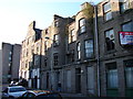
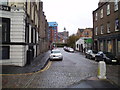

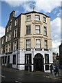
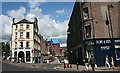


Please click the More button for more images, licensing and image copyright information.
Dundee and nearby Videos From YouTube
Ardler Dundee may 2023
A wee flyby and couple of stills of Ardler and Downfield Golf Club. Using a small 4k fitted drone, under 250g means access all ...
Channel: Strachan's Drone Services (View Channel)
Published: 26 May 2023
Member of UK Parliament
This postcode is in the Dundee East parliamentary constituency.
Dundee East is a constituency in Scotland. The seat has been held by Stewart Hosie (Scottish National Party) since May 2005.

Most Recent House Sales for King Street, DD1 2JD
No recorded house sales or transfers for this postcode.
Local Petrol Station Prices
Coordinates for DD1 2JD
Sunrise and Sunset at DD1 2JD
Traffic Emission Zones
Historical Weather Summary
| Clear | 9.07% |
| Cloudy | 51.87% |
| Rain | 7.48% |
| Windy | 31.20% |
| Other | 0.38% |
Average Energy Performance
Companies Registered at DD1 2JD
Postcode Details for DD1 2JD
Recent Updates
|
18 Apr 2024 Added Traffic Camera Views from Traffic Scotland to Roadworks within Scotland |
|
15 Apr 2024 Schools Data updated for April 2024 |
|
10 Apr 2024 Companies Data updated for March 2024 |
|
7 Apr 2024 New option to receive automatic updates to roadworks that affect you |
|
7 Apr 2024 Police and Crime data updated for February 2024 |
|
3 Apr 2024 Sold House Price data updated for February 2024 |
|
30 Mar 2024 Energy Performance Certificates (England and Wales) updated February 2024 |
|
28 Mar 2024 New feature to use Geolocating functions to detect your current location |
Random Postcodes
Want an idea of what is in our extensive website? Try somewhere completely random!
The Rural/Urban classification is based upon data collected during the 2011 Census and released in August 2013 and is categorised into 6 distinct classes.
[A] Urban Major conurbation: A built up area with a population of 10,000 (3,000 in Scotland) or more and is assigned to the major conurbation settlement category.
[B] Urban Minor conurbation: A built up area with a population of 10,000 (3,000 in Scotland) or more and is assigned to the minor conurbation settlement category.
[C] Urban City and town: A built up area with a population of 10,000 (3,000 in Scotland) or more and is assigned to the city and town settlement category.
[D] Rural Town and fringe
[E] Rural Village
[F] Rural Hamlet and isolated dwelling
The Index of Multiple Deprivation (IMD) is the official measure of relative deprivation.
The index is based on 39 separate indicators across seven distinct domains (Income; Employment; Health and Disability; Education, Skills and Training; Crime; Barriers to Housing and Services; Living Environment) to provide an overall measure of multiple deprivation and is calculated for every neighbourhood.
The index is relative rather than an absolute scale and so a neighbourhood with a score of 10 is more deprived than one rated 20, but this does not equate to being twice as deprived.
Please note: Different indices are used in England, Scotland, Wales and Northern Ireland and so comparison of scores from neighbourhoods in different countries should not be undertaken.
These figures report on incorporated UK companies only that are registered at this postcode and do not include sole-traders, partnerships or overseas organisations.
The population figure shown for your area are an estimate provided by the Office for National Statistics and is rounded to the nearest 1,000.
The estimates are derived from the Annual Population Survey (APS) which is the Labour Force Survey (LFS) plus various sample boosts.
There are 55 unitary authorities. They provide all local government services in their areas. These are mainly in the cities, urban areas and larger towns although there are now 6 shire county councils that are unitary (ie have no district councils beneath them).