Overview for Claremont Road, LEAMINGTON SPA, CV31 3EH
Introduction
Royal Leamington Spa, commonly known as Leamington Spa or simply Leamington, is a spa town and civil parish in Warwickshire, England. Originally a small village called Leamington Priors, it grew into a spa town in the 18th century following the popularisation of its water which was reputed to have medicinal qualities. In the 19th century, the town experienced one of the most rapid expansions in England. It is named after the River Leam, which flows through the town.
The town contains especially fine ensembles of Regency architecture, particularly in parts of the Parade, Clarendon Square and Lansdowne Circus. The town also contains several large public parks, such as Jephson Gardens, the Royal Pump Room Gardens and Victoria Park.
Although originally founded around its spa industry, Leamington today has developed into a centre for retail, and digital industries, which has gained it the moniker "silicon spa". In 2023 The Sunday Times named Leamington as the best place to live in the Midlands.
In the 2021 census Leamington had a population of 50,923. Leamington is adjoined with the neighbouring towns of Warwick and Whitnash, and the village of Cubbington; together these form a conurbation known as the "Royal Leamington Spa Built-up area" which in 2011 had a population of 95,172.
Leamington lies around 9 miles (14 km) south of Coventry, 20 miles (32 km) south-east of Birmingham, and 81 miles (130 km) north-west of London.
Summary for Claremont Road, LEAMINGTON SPA, CV31 3EH
Roadworks near CV31 3EH
Road Safety near CV31 3EH
Details of personal injury accidents in and around Claremont Road, CV31 3EH that have been reported to Warwickshire Police over the past 20 years.
Traffic Levels near CV31 3EH
View traffic levels near Claremont Road, CV31 3EH from official Department for Transport counts.
Images taken near to Claremont Road, CV31 3EH and the surrounding area
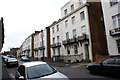
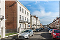
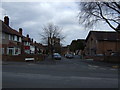
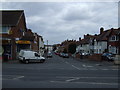
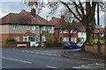
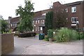
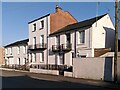
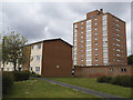
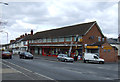
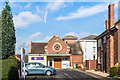
Please click the More button for more images, licensing and image copyright information.
Police
This area is policed by Warwickshire Police.
Warwickshire Police split their policing area into 33 separate neighbourhoods and this postcode is in the Leamington South neighbourhood.

Leamington South Neighbourhood Crime
Top 3 Categories
For full details of all categories together with more crime information, click on the Details button.
Member of UK Parliament
This postcode is in the Warwick and Leamington parliamentary constituency.
Warwick and Leamington is a constituency in the West Midlands region of England. The seat has been held by Matt Western (Labour) since June 2017.

Most Recent House Sales for Claremont Road, CV31 3EH
16 Nov 2018
11 Jan 2018
3 Apr 2017
9 Dec 2015
Local Petrol Station Prices
Coordinates for CV31 3EH
Residents at CV31 3EH
Sunrise and Sunset at CV31 3EH
Traffic Emission and Congestion Zones
Historical Weather Summary
| Clear | 20.76% |
| Cloudy | 68.19% |
| Rain | 6.27% |
| Windy | 4.69% |
| Other | 0.09% |
Population
Deprivation Index
the more deprived the postcode
Average Energy Performance
Companies Registered at CV31 3EH
Postcode Details for CV31 3EH
Recent Updates
|
15 Apr 2024 Schools Data updated for April 2024 |
|
10 Apr 2024 Companies Data updated for March 2024 |
|
7 Apr 2024 New option to receive automatic updates to roadworks that affect you |
|
7 Apr 2024 Police and Crime data updated for February 2024 |
|
3 Apr 2024 Sold House Price data updated for February 2024 |
|
30 Mar 2024 Energy Performance Certificates (England and Wales) updated February 2024 |
|
28 Mar 2024 New feature to use Geolocating functions to detect your current location |
|
17 Mar 2024 Schools Data updated for March 2024 |
Random Postcodes
Want an idea of what is in our extensive website? Try somewhere completely random!
The Rural/Urban classification is based upon data collected during the 2011 Census and released in August 2013 and is categorised into 6 distinct classes.
[A] Urban Major conurbation: A built up area with a population of 10,000 (3,000 in Scotland) or more and is assigned to the major conurbation settlement category.
[B] Urban Minor conurbation: A built up area with a population of 10,000 (3,000 in Scotland) or more and is assigned to the minor conurbation settlement category.
[C] Urban City and town: A built up area with a population of 10,000 (3,000 in Scotland) or more and is assigned to the city and town settlement category.
[D] Rural Town and fringe
[E] Rural Village
[F] Rural Hamlet and isolated dwelling
The Index of Multiple Deprivation (IMD) is the official measure of relative deprivation.
The index is based on 39 separate indicators across seven distinct domains (Income; Employment; Health and Disability; Education, Skills and Training; Crime; Barriers to Housing and Services; Living Environment) to provide an overall measure of multiple deprivation and is calculated for every neighbourhood.
The index is relative rather than an absolute scale and so a neighbourhood with a score of 10 is more deprived than one rated 20, but this does not equate to being twice as deprived.
Please note: Different indices are used in England, Scotland, Wales and Northern Ireland and so comparison of scores from neighbourhoods in different countries should not be undertaken.
These figures report on incorporated UK companies only that are registered at this postcode and do not include sole-traders, partnerships or overseas organisations.
The population figure shown for your area are an estimate provided by the Office for National Statistics and is rounded to the nearest 1,000.
The estimates are derived from the Annual Population Survey (APS) which is the Labour Force Survey (LFS) plus various sample boosts.
There are 26 county councils in 2-tier areas, providing services such as education, social services and waste disposal.
In 2-tier areas, each county council area is subdivided into districts, for which there is an independent district council. There are 192 district councils.
District councils are responsible for local services such as rubbish collection, housing and planning applications.