Overview for Bonds Street, LONDONDERRY, BT47 6EE
Introduction
Derry, officially Londonderry, is the second-largest city in Northern Ireland and the fifth-largest city on the island of Ireland. The old walled city lies on the west bank of the River Foyle, which is spanned by two road bridges and one footbridge. The city now covers both banks (Cityside on the west and Waterside on the east).
The population of the city was 83,652 at the 2001 Census, while the Derry Urban Area had a population of 90,736. The district administered by Derry City and Strabane District Council contains both Londonderry Port and City of Derry Airport. Derry is close to the border with County Donegal, with which it has had a close link for many centuries. The person traditionally seen as the founder of the original Derry is Saint Colmcille, a holy man from Tír Chonaill, the old name for almost all of modern County Donegal, of which the west bank of the Foyle was a part before 1610.
In 2013, Derry was the inaugural UK City of Culture, having been awarded the title in 2010.
Summary for Bonds Street, LONDONDERRY, BT47 6EE
Roadworks near BT47 6EE
Local roadworks in Northern Ireland are provided by Traffic Watch NI on their website at trafficwatchni.com/twni/traffic-news.
Unfortunately, whilst the information is provided, the orgasation do not provide location coordinates and so we are unable to map the planned works to local postcodes at this time.
Road Safety near BT47 6EE
Details of personal injury accidents in and around Bonds Street, BT47 6EE that have been reported to Police Service of Northern Ireland over the past 20 years.
Traffic Levels near BT47 6EE
View traffic levels near Bonds Street, BT47 6EE from official Department for Transport counts.
Images taken near to Bonds Street, BT47 6EE and the surrounding area
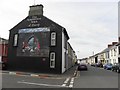
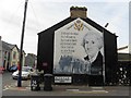

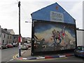

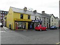
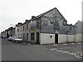
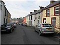
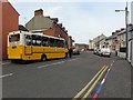
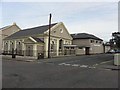
Please click the More button for more images, licensing and image copyright information.
Police
This area is policed by Police Service of Northern Ireland.
Police Service of Northern Ireland split their policing area into 26 separate neighbourhoods and this postcode is in the Strand Road neighbourhood.

Strand Road Neighbourhood Crime
Top 3 Categories
For full details of all categories together with more crime information, click on the Details button.
Member of UK Parliament
Unfortunately, Parliamentary details are not available for this postcode.
Most Recent House Sales for Bonds Street, BT47 6EE
No recorded house sales or transfers for this postcode.
Local Petrol Station Prices
Coordinates for BT47 6EE
Sunrise and Sunset at BT47 6EE
Traffic Emission and Congestion Zones
Historical Weather Summary
| Clear | 14.53% |
| Cloudy | 61.62% |
| Rain | 12.39% |
| Windy | 9.87% |
| Other | 1.59% |
Companies Registered at BT47 6EE
Postcode Details for BT47 6EE
Recent Updates
|
18 Apr 2024 Added Traffic Camera Views from Traffic Scotland to Roadworks within Scotland |
|
15 Apr 2024 Schools Data updated for April 2024 |
|
10 Apr 2024 Companies Data updated for March 2024 |
|
7 Apr 2024 New option to receive automatic updates to roadworks that affect you |
|
7 Apr 2024 Police and Crime data updated for February 2024 |
|
3 Apr 2024 Sold House Price data updated for February 2024 |
|
30 Mar 2024 Energy Performance Certificates (England and Wales) updated February 2024 |
|
28 Mar 2024 New feature to use Geolocating functions to detect your current location |
Random Postcodes
Want an idea of what is in our extensive website? Try somewhere completely random!
The Rural/Urban classification is based upon data collected during the 2011 Census and released in August 2013 and is categorised into 6 distinct classes.
[A] Urban Major conurbation: A built up area with a population of 10,000 (3,000 in Scotland) or more and is assigned to the major conurbation settlement category.
[B] Urban Minor conurbation: A built up area with a population of 10,000 (3,000 in Scotland) or more and is assigned to the minor conurbation settlement category.
[C] Urban City and town: A built up area with a population of 10,000 (3,000 in Scotland) or more and is assigned to the city and town settlement category.
[D] Rural Town and fringe
[E] Rural Village
[F] Rural Hamlet and isolated dwelling
The Index of Multiple Deprivation (IMD) is the official measure of relative deprivation.
The index is based on 39 separate indicators across seven distinct domains (Income; Employment; Health and Disability; Education, Skills and Training; Crime; Barriers to Housing and Services; Living Environment) to provide an overall measure of multiple deprivation and is calculated for every neighbourhood.
The index is relative rather than an absolute scale and so a neighbourhood with a score of 10 is more deprived than one rated 20, but this does not equate to being twice as deprived.
Please note: Different indices are used in England, Scotland, Wales and Northern Ireland and so comparison of scores from neighbourhoods in different countries should not be undertaken.
These figures report on incorporated UK companies only that are registered at this postcode and do not include sole-traders, partnerships or overseas organisations.
The population figure shown for your area are an estimate provided by the Office for National Statistics and is rounded to the nearest 1,000.
The estimates are derived from the Annual Population Survey (APS) which is the Labour Force Survey (LFS) plus various sample boosts.
There are 26 county councils in 2-tier areas, providing services such as education, social services and waste disposal.
In 2-tier areas, each county council area is subdivided into districts, for which there is an independent district council. There are 192 district councils.
District councils are responsible for local services such as rubbish collection, housing and planning applications.