Overview for St. Marks Road, BRISTOL, BS5 6JQ
Introduction
Bristol is a city, ceremonial county and unitary authority in England. On the River Avon, it is bordered by the ceremonial counties of Gloucestershire to the north and Somerset to the south. It is in the West of England Combined Authority and the most populous city in South West England.
The wider Bristol Built-up Area is the eleventh most populous urban area in the United Kingdom.
Iron Age hillforts and Roman villas were built near the confluence of the rivers Frome and Avon. Around the beginning of the 11th century, the settlement was known as Brycgstow . Bristol received a royal charter in 1155 and was historically divided between Gloucestershire and Somerset until 1373 when it became a county corporate. From the 13th to the 18th century, Bristol was among the top three English cities, after London, in tax receipts.
A major port, Bristol was a starting place for early voyages of exploration to the New World. On a ship out of Bristol in 1497, John Cabot, a Venetian, became the first European to land on mainland North America. In 1499, William Weston, a Bristol merchant, was the first Englishman to lead an exploration to North America. At the height of the Bristol slave trade, from 1700 to 1807, more than 2,000 slave ships carried an estimated 500,000 people from Africa to slavery in the Americas. The Port of Bristol has since moved from Bristol Harbour in the city centre to the Severn Estuary at Avonmouth and Royal Portbury Dock.
Bristol's modern economy is built on the creative media, electronics and aerospace industries; the city-centre docks have been redeveloped as centres of heritage and culture. The city had the largest circulating community currency in the UK, the Bristol Pound, which was pegged to the pound sterling before it ceased operation in August 2020. The city has two universities: the University of Bristol and the University of the West of England (UWE Bristol). There are a variety of artistic and sporting organisations and venues including the Royal West of England Academy, the Arnolfini, Spike Island, Ashton Gate and the Memorial Stadium. It is connected to London and other major UK cities by road and rail, and to the world by sea and air: road, by the M5 and M4 (which connect to the city centre by the Portway and M32); rail, via Bristol Temple Meads and Bristol Parkway mainline rail stations; and Bristol Airport.
Bristol was named the best city in Britain in which to live in 2014 and 2017; it won the European Green Capital Award in 2015.
Summary for St. Marks Road, BRISTOL, BS5 6JQ
Roadworks near BS5 6JQ
Road Safety near BS5 6JQ
Details of personal injury accidents in and around St. Marks Road, BS5 6JQ that have been reported to Avon and Somerset Constabulary over the past 20 years.
Traffic Levels near BS5 6JQ
View traffic levels near St. Marks Road, BS5 6JQ from official Department for Transport counts.
Images taken near to St. Marks Road, BS5 6JQ and the surrounding area
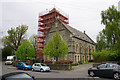
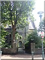
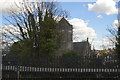
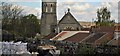
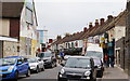
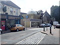
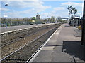
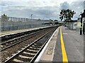
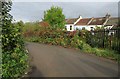
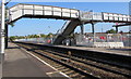
Please click the More button for more images, licensing and image copyright information.
Bristol and nearby Videos From YouTube
View around Old Bristolians Failand Bristol Drone Video
OLd Bristolians Rugby. This is Failand.
Channel: Paul Tinks (View Channel)
Published: 14 May 2020
Police
This area is policed by Avon and Somerset Constabulary.
Avon and Somerset Constabulary split their policing area into 123 separate neighbourhoods and this postcode is in the Easton and Redfield neighbourhood.

Easton and Redfield Neighbourhood Crime
Top 3 Categories
For full details of all categories together with more crime information, click on the Details button.
Member of UK Parliament
This postcode is in the Bristol West parliamentary constituency.
Bristol West is a constituency in the South West region of England. The seat has been held by Thangam Debbonaire (Labour) since May 2015.

Most Recent House Sales for St. Marks Road, BS5 6JQ
No recorded house sales or transfers for this postcode.
Local Petrol Station Prices
Coordinates for BS5 6JQ
Residents at BS5 6JQ
Sunrise and Sunset at BS5 6JQ
Traffic Emission and Congestion Zones
Historical Weather Summary
| Clear | 20.61% |
| Cloudy | 70.28% |
| Rain | 7.55% |
| Windy | 1.36% |
| Other | 0.20% |
Population
Deprivation Index
the more deprived the postcode
Average Energy Performance
Companies Registered at BS5 6JQ
Postcode Details for BS5 6JQ
Recent Updates
|
15 Apr 2024 Schools Data updated for April 2024 |
|
10 Apr 2024 Companies Data updated for March 2024 |
|
7 Apr 2024 New option to receive automatic updates to roadworks that affect you |
|
7 Apr 2024 Police and Crime data updated for February 2024 |
|
3 Apr 2024 Sold House Price data updated for February 2024 |
|
30 Mar 2024 Energy Performance Certificates (England and Wales) updated February 2024 |
|
28 Mar 2024 New feature to use Geolocating functions to detect your current location |
|
17 Mar 2024 Schools Data updated for March 2024 |
Random Postcodes
Want an idea of what is in our extensive website? Try somewhere completely random!
The Rural/Urban classification is based upon data collected during the 2011 Census and released in August 2013 and is categorised into 6 distinct classes.
[A] Urban Major conurbation: A built up area with a population of 10,000 (3,000 in Scotland) or more and is assigned to the major conurbation settlement category.
[B] Urban Minor conurbation: A built up area with a population of 10,000 (3,000 in Scotland) or more and is assigned to the minor conurbation settlement category.
[C] Urban City and town: A built up area with a population of 10,000 (3,000 in Scotland) or more and is assigned to the city and town settlement category.
[D] Rural Town and fringe
[E] Rural Village
[F] Rural Hamlet and isolated dwelling
The Index of Multiple Deprivation (IMD) is the official measure of relative deprivation.
The index is based on 39 separate indicators across seven distinct domains (Income; Employment; Health and Disability; Education, Skills and Training; Crime; Barriers to Housing and Services; Living Environment) to provide an overall measure of multiple deprivation and is calculated for every neighbourhood.
The index is relative rather than an absolute scale and so a neighbourhood with a score of 10 is more deprived than one rated 20, but this does not equate to being twice as deprived.
Please note: Different indices are used in England, Scotland, Wales and Northern Ireland and so comparison of scores from neighbourhoods in different countries should not be undertaken.
These figures report on incorporated UK companies only that are registered at this postcode and do not include sole-traders, partnerships or overseas organisations.
The population figure shown for your area are an estimate provided by the Office for National Statistics and is rounded to the nearest 1,000.
The estimates are derived from the Annual Population Survey (APS) which is the Labour Force Survey (LFS) plus various sample boosts.
There are 55 unitary authorities. They provide all local government services in their areas. These are mainly in the cities, urban areas and larger towns although there are now 6 shire county councils that are unitary (ie have no district councils beneath them).