IMAGES TAKEN NEAR TO
Otterwood Paddock, YORK, YO41 1BA
Introduction
This page details the photographs taken nearby to Otterwood Paddock, YO41 1BA by members of the Geograph project.
The Geograph project started in 2005 with the aim of publishing, organising and preserving representative images for every square kilometre of Great Britain, Ireland and the Isle of Man.

There are currently over 7.5m images from over14,400 individuals and you can help contribute to the project by visiting https://www.geograph.org.uk
Image Map (Loading...)


Getting Data...Please wait
Leaflet Map data © OpenStreetMap
Images are licensed for reuse under creativecommons.org/licenses/by-sa/2.0
Notes
- Clicking on the map will re-center to the selected point.
- The higher the marker number, the further away the image location is from the centre of the postcode.
Image Listing (35 Images Found)
Images are licensed for reuse under creativecommons.org/licenses/by-sa/2.0
Image
Details
Distance
1

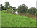
River Derwent at Stamford Bridge
Seen at the western end of the village, close to the footpath to Low Catton
Image: © Paul Harrop
Taken: 17 Jun 2013
0.10 miles
2
River Derwent, Stamford Bridge
From the riverside footpath. The Derwent is running south to join the Ouse.
Image: © Pauline E
Taken: 26 Aug 2012
0.11 miles
3

River Derwent near Stamford Bridge
Looking downstream close to the western end of the village, close to the footpath to Low Catton
Image: © Paul Harrop
Taken: 17 Jun 2013
0.11 miles
4
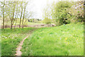
Approaching the Derwent
The view is north, and the path curves north east to join the bank of the river Derwent, and so to Stamford Bridge.
Image: © Peter Church
Taken: 5 May 2012
0.13 miles
5
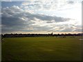
Stamford Bridge Cricket Club
A match is underway on a late spring evening in Stamford Bridge.
Image: © DS Pugh
Taken: 22 Apr 2010
0.15 miles
6

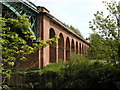
Houses in Stamford Bridge
Looking across from the viaduct above the River Derwent.
Image: © DS Pugh
Taken: 15 Apr 2021
0.16 miles
7
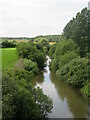
Downstream along the Derwent
The Derwent isn't a large river, the overhanging vegetation here making it look even narrower than it is. The Derwent drains most of the southern half of the North York Moors and is prone to flooding.
Image: © Gordon Hatton
Taken: 9 Aug 2021
0.18 miles
9

River Derwent in flood
Looking down onto the River Derwent from the viaduct.
Image: © DS Pugh
Taken: 20 Dec 2020
0.19 miles
10

Northwest Catton
Public footpath from Stamford Bridge to Church Lane, Low Catton, in the northwest corner of Catton parish just east of the River Derwent.
Image: © Paul Glazzard
Taken: 4 Aug 2008
0.20 miles