IMAGES TAKEN NEAR TO
Constantine Avenue, YORK, YO10 3SY
Introduction
This page details the photographs taken nearby to Constantine Avenue, YO10 3SY by members of the Geograph project.
The Geograph project started in 2005 with the aim of publishing, organising and preserving representative images for every square kilometre of Great Britain, Ireland and the Isle of Man.

There are currently over 7.5m images from over14,400 individuals and you can help contribute to the project by visiting https://www.geograph.org.uk
Image Map (Loading...)


Getting Data...Please wait
Leaflet Map data © OpenStreetMap
Images are licensed for reuse under creativecommons.org/licenses/by-sa/2.0
Notes
- Clicking on the map will re-center to the selected point.
- The higher the marker number, the further away the image location is from the centre of the postcode.
Image Listing (149 Images Found)
Images are licensed for reuse under creativecommons.org/licenses/by-sa/2.0
Image
Details
Distance
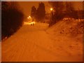
1
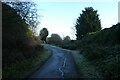
Frosty cycle path
Looking towards Tang Hall.
Image: © DS Pugh
Taken: 7 Jan 2021
0.04 miles
2
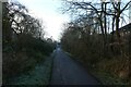
Path approaching Melrosegate
Looking along the Sustrans cycle path through Layerthorpe.
Image: © DS Pugh
Taken: 7 Jan 2021
0.04 miles
3
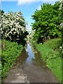
Temporary Ford - Route 66
This is between Tang Hall bridge and Melrose Gate bridge (viewable in the back of the picture), along the Osbaldwick - York city centre section of Sustrans route 66. The prolonged rainfall for the past week has caused this section to become quite flooded. It may not look deep but I can assure you it was more than a foot in the centre!
Image: © DS Pugh
Taken: 23 May 2006
0.04 miles
4
Sustrans route at Melrosegate
Part of the Sustrans cycle route between the Nestle site and Osbaldwick.
Image: © DS Pugh
Taken: 4 Feb 2012
0.05 miles
5
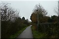
Cycle path to Osbaldwick
Looking along the Sustrans cycle path from Foss Islands.
Image: © DS Pugh
Taken: 12 Mar 2021
0.06 miles
6
Big Blue Pipe, east of Melrosegate
One of ten painted steel sculptures by George Cutts, commissioned by Sustrans in the 1980s. Alongside the Foss Island Path, part of NCR route 66. This is the former route of the Derwent Valley Light Railway.
Image: © Christine Johnstone
Taken: 22 Oct 2022
0.06 miles
7

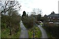
Melrosegate Bridge
Looking along the cycle path between Osbaldwick and Crichton Avenue.
Image: © DS Pugh
Taken: 18 Jan 2021
0.07 miles
8
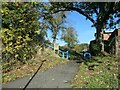
Path towards Melrosegate
Looking along the Sustrans cycle path NCN66.
Image: © DS Pugh
Taken: 19 Dec 2021
0.07 miles
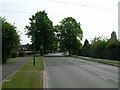
10
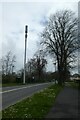
Communications tower on Melrosegate
Looking over the bridge above the cycle path and former railway.
Image: © DS Pugh
Taken: 13 Apr 2022
0.07 miles