1
Looking up Humber road, Ronkswood estate
Calder road goes off the right hand edge of the photograph. This part of the ronkswood estate has roads named after rivers. Further up the hill, closer to the hospital, the roads are named after cathedral cities. Another Worcester estate has roads named after places in the Lake District. The trees seen behind the houses in the distance are Perry Wood.
Image: © Chris Allen
Taken: 6 Sep 2019
0.02 miles
2
Roadworks Newtown Road, Worcester
At the junction with Humber Road.
Image: © Chris Allen
Taken: 12 Feb 2024
0.06 miles
3
Newtown Road
View westwards as the road starts to descend towards Shrub Hill Station. This busy road takes traffic from J7 of the M5 into the city centre.
Image: © Trevor Rickard
Taken: 11 Dec 2007
0.06 miles
4
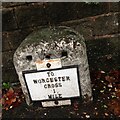
Old Milestone, B4636, Newtown Road, Worcester
The milestone is located by No. 69, opposite Humber Road, on the north side of the road, which is the route of the Worcester Trust Turnpike to Bradley Green. Parish of Worcester (Worcester District). Metal plate attached to stone post. Re-plated Worcester stone design, erected by the Worcester turnpike trust in the 19th century. Re-plated by members of The Milestone Society in 2008.
Inscription reads:-
TO
WORCESTER
CROSS
1
MILE
Milestone Society National ID: WO_WOFK01
Image: © Jan Scrine
Taken: 27 Jan 2022
0.07 miles
5
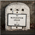
Old Milestone, B4636, Newtown Road, Worcester
The milestone is located by No. 69, opposite Humber Road, on the north side of the road, which is the route of the Worcester Trust Turnpike to Bradley Green. Parish of Worcester (Worcester District). Metal plate attached to stone post. Re-plated Worcester stone design, erected by the Worcester turnpike trust in the 19th century. Re-plated by members of The Milestone Society in 2008.
Inscription reads:-
TO
WORCESTER
CROSS
1
MILE
Milestone Society National ID: WO_WOFK01
Image: © Jan Scrine
Taken: 28 Nov 2018
0.07 miles
6
Old Milestone, B4636, Newtown Road, Worcester
The milestone is located by No. 69, opposite Humber Road, on the north side of the road, which is the route of the Worcester Trust Turnpike to Bradley Green. Parish of Worcester (Worcester District). Metal plate attached to stone post. Re-plated Worcester stone design, erected by the Worcester turnpike trust in the 19th century. Re-plated by members of The Milestone Society in 2008.
Inscription reads:-
TO
WORCESTER
CROSS
1
MILE
Milestone Society National ID: WO_WOFK01
Image: © Peter Willis
Taken: Unknown
0.07 miles
7
Newtown Road (B4636), Worcester
Looking east.
Image: © JThomas
Taken: 8 Apr 2017
0.08 miles
8
Medway Road, Worcester
Social housing on streets named after rivers. Medway Road seems to be in two separate halves separated by Hamble Close. The houses crossing at the end are on Humber Road.
Image: © Chris Allen
Taken: 9 Feb 2023
0.11 miles
9
Newtown Road Cantonese Take-away, 41 Newtown Road, Worcester
A Chinese (Cantonese style) takeaway located on the corner of Newtown Road and Ronkswood Hill. Around the side at No. 43 Newtown Road, was Cowleys, newsagents, but the shop looked disused.
Image: © P L Chadwick
Taken: 6 Sep 2014
0.12 miles
10
Solent Road
Solent Road in Ronkswood, Worcester.
Image: © Philip Halling
Taken: 1 Jul 2009
0.12 miles


