IMAGES TAKEN NEAR TO
Tanglewood Heights, MALVERN, WR14 1GN
Introduction
This page details the photographs taken nearby to Tanglewood Heights, WR14 1GN by members of the Geograph project.
The Geograph project started in 2005 with the aim of publishing, organising and preserving representative images for every square kilometre of Great Britain, Ireland and the Isle of Man.

There are currently over 7.5m images from over14,400 individuals and you can help contribute to the project by visiting https://www.geograph.org.uk
Image Map (Loading...)


Getting Data...Please wait
Leaflet Map data © OpenStreetMap
Images are licensed for reuse under creativecommons.org/licenses/by-sa/2.0
Notes
- Clicking on the map will re-center to the selected point.
- The higher the marker number, the further away the image location is from the centre of the postcode.
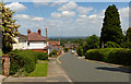
Image Listing (72 Images Found)
Images are licensed for reuse under creativecommons.org/licenses/by-sa/2.0
Image
Details
Distance
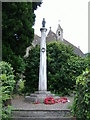
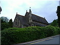
4
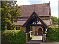
Lych gate at St. Peter's Church
Along Cowleigh Bank in the spa town of Malvern.
Image: © Mat Fascione
Taken: 12 Jun 2014
0.08 miles
5
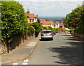
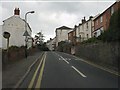
Blackmore Road in Malvern
At the junction with St Peter's Road.
Image: © Mat Fascione
Taken: 12 Jun 2014
0.09 miles
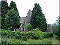
8
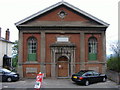
North Malvern Congregational Church
Formally opened in Cowleigh Road on the 28th June 1853.
Image: © Bob Embleton
Taken: 13 Aug 2014
0.10 miles
10
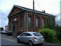
North Malvern - Cowleigh Road
Faded lettering on the building on the left reveals it to once have been the Cowleigh Arms free house and off licence. It is now a private dwelling.
Image: © Peter Whatley
Taken: 21 Mar 2011
0.12 miles