IMAGES TAKEN NEAR TO
Warren Ridge, TUNBRIDGE WELLS, TN3 9EE
Introduction
This page details the photographs taken nearby to Warren Ridge, TN3 9EE by members of the Geograph project.
The Geograph project started in 2005 with the aim of publishing, organising and preserving representative images for every square kilometre of Great Britain, Ireland and the Isle of Man.

There are currently over 7.5m images from over14,400 individuals and you can help contribute to the project by visiting https://www.geograph.org.uk
Image Map (Loading...)


Getting Data...Please wait
Leaflet Map data © OpenStreetMap
Images are licensed for reuse under creativecommons.org/licenses/by-sa/2.0
Notes
- Clicking on the map will re-center to the selected point.
- The higher the marker number, the further away the image location is from the centre of the postcode.
Image Listing (257 Images Found)
Images are licensed for reuse under creativecommons.org/licenses/by-sa/2.0
Image
Details
Distance
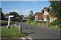
2
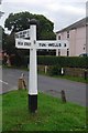
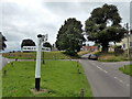
Direction Sign - Signpost by The Green, Frant
Black iron cap finial - 3 arms; East Sussex wood by the UC road, in parish of Frant (Wealden District), The Green junction with High Street and Bells Yew Green Road, on grass island at junction.
Surveyed
Milestone Society National ID: SX_TQ5935
Image: © Milestone Society
Taken: Unknown
0.05 miles