IMAGES TAKEN NEAR TO
Winchet Hill, CRANBROOK, TN17 1JX
Introduction
This page details the photographs taken nearby to Winchet Hill, TN17 1JX by members of the Geograph project.
The Geograph project started in 2005 with the aim of publishing, organising and preserving representative images for every square kilometre of Great Britain, Ireland and the Isle of Man.

There are currently over 7.5m images from over14,400 individuals and you can help contribute to the project by visiting https://www.geograph.org.uk
Image Map (Loading...)


Getting Data...Please wait
Leaflet Map data © OpenStreetMap
Images are licensed for reuse under creativecommons.org/licenses/by-sa/2.0
Notes
- Clicking on the map will re-center to the selected point.
- The higher the marker number, the further away the image location is from the centre of the postcode.
Image Listing (32 Images Found)
Images are licensed for reuse under creativecommons.org/licenses/by-sa/2.0
Image
Details
Distance
1
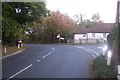
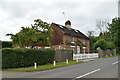
The B2079 Goudhurst Road junction at Winchet Hill
The road leads from Goudhurst and Brandfold to Marden. Jarvis Lane leads right towards Worms Hill. Paygate Cottage is seen in the background on the right.
Image: © David Anstiss
Taken: 27 Sep 2009
0.07 miles
2
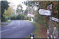
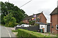
The B2079 Goudhurst Road at Winchet Hill
This road leads from Goudhurst and Brandfold towards Marden Beech and Marden.
Woolpack Cottage is seen on the right. Seen from Jarvis lane junction.
Image: © David Anstiss
Taken: 27 Sep 2009
0.07 miles
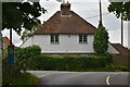
5
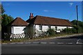
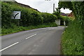
Old Toll House by the B2079, Winchet Hill
Toll House in the parish of Goudhurst (Tunbridge Wells District), Paygate (opposite Toll Cottage), Winchet Hill (B2079) at the junction with Curtisden Green Lane, TN17 1LA.
Surveyed
Milestone Society National ID: KE.MAD01
Image: © Milestone Society
Taken: Unknown
0.08 miles
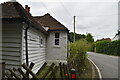
6
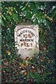
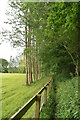
Old Milestone, B2079, Winchet Hill, Layden
The milestone is located on the verge under ivy, on the south side of the road. Parish of Marden (Maidstone District). Metal plate attached to stone post, Marden iron plate design, erected by the Goudhurst Gore & Stilebridge turnpike trust in the 19th century.
Inscription reads:- : MAIDSTONE / 10¾ / MARDEN / 3 :
Milestone Society National ID: KE_MDMA11
Image: © Colin Woodward
Taken: Unknown
0.09 miles