IMAGES TAKEN NEAR TO
Shearston, BRIDGWATER, TA6 6PG
Introduction
This page details the photographs taken nearby to Shearston, TA6 6PG by members of the Geograph project.
The Geograph project started in 2005 with the aim of publishing, organising and preserving representative images for every square kilometre of Great Britain, Ireland and the Isle of Man.

There are currently over 7.5m images from over14,400 individuals and you can help contribute to the project by visiting https://www.geograph.org.uk
Image Map (Loading...)


Getting Data...Please wait
Leaflet Map data © OpenStreetMap
Images are licensed for reuse under creativecommons.org/licenses/by-sa/2.0
Notes
- Clicking on the map will re-center to the selected point.
- The higher the marker number, the further away the image location is from the centre of the postcode.
Image Listing (14 Images Found)
Images are licensed for reuse under creativecommons.org/licenses/by-sa/2.0
Image
Details
Distance
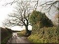
1
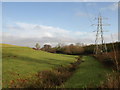
Valley below King's Farm
From the lane shown in Image, looking downstream towards where the same valley is crossed by Image Just discernible through the trees above the stream are the houses shown in Image
Image: © Derek Harper
Taken: 16 Jan 2010
0.11 miles
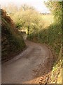
2
Haddon Lane (2)
Taken further down the hill shown in Image, with the lane climbing the far side of the valley towards King's Farm, which is in Image
Image: © Derek Harper
Taken: 16 Jan 2010
0.13 miles
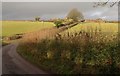
3
Haddon Lane
The lane disappearing off to the right in Image, dropping down to cross the same valley as Image, about 350 metres further up it.
Image: © Derek Harper
Taken: 16 Jan 2010
0.14 miles
4
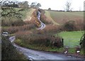
Lane to Farringdon
The lane sinuously crosses the valley shown in Image - the parked car appears in both. Footpath BW 23/76 leads off through the metal gate on the right.
Image: © Derek Harper
Taken: 16 Jan 2010
0.14 miles
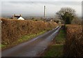
5
Lane junction north of Thurloxton
Howell's Lane progresses up a ridge, with Haddon Lane dropping to the right, and a lane to Thurloxton turning off to the left a few metres beyond.
Image: © Derek Harper
Taken: 16 Jan 2010
0.16 miles
6
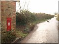
Postbox, Shearston
A Victorian postbox, number TA6 20, in the wall of a barn opposite the old smithy at Shearston. On the right is a lane junction; straight ahead is Howells Lane, for Thurloxton, and right is Image
Image: © Derek Harper
Taken: 16 Jan 2010
0.18 miles
7
Haddon Lane (3)
A straight stretch of the lane drops towards King's Farm (left). Straight ahead across the valley are Image
Image: © Derek Harper
Taken: 16 Jan 2010
0.18 miles
8
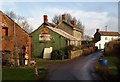
Former blacksmiths and garage, Shearston
Image: © Roger Cornfoot
Taken: 14 Feb 2015
0.18 miles
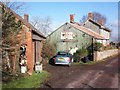
9
Buildings at Shearston
The buildings on the left are shown on the maps as a smithy. Taken from close to Image
Image: © Derek Harper
Taken: 16 Jan 2010
0.19 miles
