IMAGES TAKEN NEAR TO
Higher Heath, WHITCHURCH, SY13 2HU

Introduction

This page details the photographs taken nearby to SY13 2HU by members of the Geograph project.

The Geograph project started in 2005 with the aim of publishing, organising and preserving representative images for every square kilometre of Great Britain, Ireland and the Isle of Man.

There are currently over 7.5m images from over14,400 individuals and you can help contribute to the project by visiting https://www.geograph.org.uk

Image Map


Images are licensed for reuse under creativecommons.org/licenses/by-sa/2.0
Notes
  • Clicking on the map will re-center to the selected point.
  • The higher the marker number, the further away the image location is from the centre of the postcode.

Image Listing (8 Images Found)

Images are licensed for reuse under creativecommons.org/licenses/by-sa/2.0
Image
Details
Distance
1
House on Green Lane
Image: © JThomas Taken: 3 Jul 2024
0.01 miles
2
Elizabeth II postbox on Green Lane, Upper College
Postbox No. SY13 746.
Image: © JThomas Taken: 3 Jul 2024
0.01 miles
3
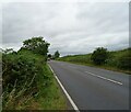
A41 at Upper College
Image: © Peter Whatley Taken: 17 Jan 2012
0.01 miles
4
A41, Upper College
Image: © JThomas Taken: 3 Jul 2024
0.16 miles
5
Manor House Lane
Image: © JThomas Taken: 3 Jul 2024
0.18 miles
6
Maize field, Upper College
Image: © JThomas Taken: 3 Jul 2024
0.20 miles
7
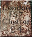
Old Milestone formerly on the A41, Prees parish
Metal plate was on the A41, in parish of PREES (NORTH SHROPSHIRE District), was just South of Hawk & Buckle Farm, is now in private possession. Erected by the Whitchurch to Ternhill turnpike trust in the 19th century. N.B. see further information on HER link. Inscription reads:- LONDON 157 Chester 24 Shropshire HER. HER Number (PRN): 29274 https://www.heritagegateway.org.uk/Gateway/Results_Single.aspx?uid=MSA33351&resourceID=1015 Milestone Society National ID: SA_CHNP24.
Image: © Milestone Society Taken: Unknown
0.20 miles
8
Green Lane towards Prees
Image: © JThomas Taken: 3 Jul 2024
0.20 miles