1
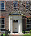
166 Roehampton Lane, Putney Heath
Used by Citizens Advice Centre, South Thames College, and a Surestart children's daycare centre.
Image: © David Anstiss
Taken: 30 Dec 2012
0.01 miles
2
Downshire House, Roehampton
Grade II listed building on Roehampton Lane.
Built in 1770 and once occupied by the Marquess of Downshire.
Currently used by the University of Roehampton.
See http://www.britishlistedbuildings.co.uk/en-207117-downshire-house-greater-london-authority for more details on the house.
Image: © David Anstiss
Taken: 30 Dec 2012
0.03 miles
3
Detail of Downshire House, Roehampton Lane
The house itself (c1770, possibly by Robert Brettingham) is very plain but has a fine doorcase with a rusticated surround, fluted Doric pilasters, triglyph frieze and segmental pediment. Grade II* listed.
Image: © Stephen Richards
Taken: 26 Mar 2012
0.03 miles
4
Tree, Roehampton Lane
Probably a pine of some description.
Roehampton was a favoured area for country villas (an unusually high proportion of which survive), and, despite extensive modern development, many fine mature trees from their grounds have been preserved.
Image: © Stephen Richards
Taken: 26 Mar 2012
0.04 miles
5
Cedar, Highcliffe Drive
A beautiful Cedar of Lebanon between the Alton West Estate and Roehampton Lane.
Roehampton was a favoured area for country villas (an unusually high proportion of which survive), and, despite extensive modern development, many fine mature trees from their grounds have been preserved.
Image: © Stephen Richards
Taken: 26 Mar 2012
0.08 miles
6
Binley House, Highcliffe Drive
One of a group of 5 apartment blocks along the road.
Found out later, this building and the other apartment blocks are Grade II* listed. See http://www.britishlistedbuildings.co.uk/en-472038-binley-house-greater-london-authority for more details.
'probably the finest low-cost housing development in the world' (G E Kidder Smith) was said about them...!
Image: © David Anstiss
Taken: 30 Dec 2012
0.08 miles
7
Alton West Estate, Roehampton, 1966 ? 2
Image: © Alan Murray-Rust
Taken: 25 Apr 1966
0.08 miles
8
Roehampton from the air
The towerblocks are at Highcliffe Drive. Richmond Park Golf Club is in the background.
Image: © Thomas Nugent
Taken: 19 Jun 2015
0.09 miles
9
Housing blocks, Alton West Estate, Roehampton
Two of a series of five 'slab' blocks - Dunbridge House, Denmead House, Charcot House, Winchfield House, and Binley House - built in the 1950s to the designs of the London County Council Architects' Department. Grade II* listed - "They are the centrepiece of the Alton West estate, the LCC's most ambitious post-war development scheme and considered 'probably the finest low-cost housing development in the world' (G E Kidder Smith). It remains very highly regarded." - quoted from this https://historicengland.org.uk/listing/the-list/list-entry/1246040.
Image: © Jim Osley
Taken: 10 Oct 2015
0.09 miles
10
Alton West Estate, Roehampton, 1966 ? 9
Image: © Alan Murray-Rust
Taken: 25 Apr 1966
0.10 miles


