1
Approach to East Putney station
Image: © David Howard
Taken: 4 May 2008
0.03 miles
2
Railway arch
Image: © N Chadwick
Taken: 31 Mar 2016
0.03 miles
3
Putney : Upper Richmond Road A205
Looking along the A205.
Image: © Lewis Clarke
Taken: 27 Jun 2022
0.03 miles
4
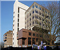
SWG House, Wandsworth
Large modern building on the junction of Keswick Road (in front) and Upper Richmond Road. The lower floor is used by a Co-Operative supermarket.
Image: © David Anstiss
Taken: 14 Apr 2013
0.03 miles
5
Bridges on Point Pleasant Junction - East Putney spur
The far bridge, just glimpsed on a diverging alignment, is disused as the up line of the Point Pleasant flying junction has been abandoned. The near down line bridge is still in use as a single line, used principally for empty trains to Wimbledon depot.
Image: © Robin Webster
Taken: 14 Apr 2012
0.04 miles
6
Railway bridges over Woodlands Way, Wandsworth
Woodlands Way leads from Upper Richmond Road to Fawe Park Road under these bridges.
The bridges were built by the London and South Western Railway (L&SWR) which, starting on 1 July 1889, ran its own trains over the line via an eastward-facing loop that joins the Clapham Junction to Barnes mainline.
The near bridge is currently used as a shunting line from Wandsworth Town Station (heading right) to East Putney Station, used by empty stock trains or occasional diversions by Southwest Trains when the line between Wimbledon and Clapham Junction needs to be avoided.
The other bridge is disused.
Image: © David Anstiss
Taken: 14 Apr 2013
0.04 miles
7
Railway bridges over Upper Richmond Road
The near bridge is a Network Rail bridge on the Point Pleasant Junction - East Putney spur. The far bridge (where the bus is) is for the District Line, Wimbledon branch. In the vee between the converging lines on the left is the entrance to East Putney station, now only served by the District Line.
Image: © Robin Webster
Taken: 14 Apr 2012
0.04 miles
8
Disused platform at East Putney
The station was opened by the Metropolitan District Railway in 1889 on an extension from Putney Bridge station to Wimbledon. The District Line tracks are out of the picture to the left. The tracks here are used by empty stock trains or occasional diversions by Southwest Trains when the line between Wimbledon and Clapham Junction needs to be avoided. The disused platform on the right hand side of the photograph was last used by stopping passenger trains in 1941.
Image: © Marathon
Taken: 16 Feb 2011
0.04 miles
9
Bridges on Point Pleasant Junction - East Putney spur
The near bridge is disused as the up line of the Point Pleasant flying junction has been abandoned. The far down line bridge, just glimpsed on a converging alignment, is still in use as a single line.
Image: © Robin Webster
Taken: 14 Apr 2012
0.04 miles
10
86-90 Upper Richmond Road
An unfeasibly ugly 1970s/1980s jumble which has been demolished since this photo was taken.
Inevitably, flats and offices to follow.
Image: © Stephen Richards
Taken: 13 Mar 2012
0.05 miles


