IMAGES TAKEN NEAR TO
High Street, NEWCASTLE, ST5 6DD
Introduction
This page details the photographs taken nearby to High Street, ST5 6DD by members of the Geograph project.
The Geograph project started in 2005 with the aim of publishing, organising and preserving representative images for every square kilometre of Great Britain, Ireland and the Isle of Man.

There are currently over 7.5m images from over14,400 individuals and you can help contribute to the project by visiting https://www.geograph.org.uk
Image Map (Loading...)


Getting Data...Please wait
Leaflet Map data © OpenStreetMap
Images are licensed for reuse under creativecommons.org/licenses/by-sa/2.0
Notes
- Clicking on the map will re-center to the selected point.
- The higher the marker number, the further away the image location is from the centre of the postcode.
Image Listing (12 Images Found)
Images are licensed for reuse under creativecommons.org/licenses/by-sa/2.0
Image
Details
Distance
1
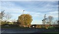
Knutton: Oak Road meets Black Bank Road
Opposite the road junction at the foot of Black Bank, the gated lane is also a public footpath, Newcastle FP 61.
Image: © Jonathan Hutchins
Taken: 12 Nov 2015
0.05 miles
2

Knutton: site of demolished semi-detached house
No.53 High Street was boarded up for at least seven years prior to the date of this photo. Planning permission was granted in March 2014 for the demolition of house and garage and their replacement with two new two-storey houses, and in early July 2015 it was demolished - or, rather, carefully dismantled so as not to damage No.51, its semi-detached partner.
Image: © Jonathan Hutchins
Taken: 8 Jul 2015
0.06 miles
3
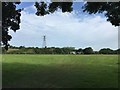
Knutton playing fields
The morning after the departure of a group of travellers who had arrived four days before. The gulls - Lesser Black-backed and Black-headed - have been at least in part attracted by the detritus left behind.
Image: © Jonathan Hutchins
Taken: 10 Jul 2015
0.07 miles
4
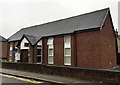
Knutton: The decline of Methodism
This former Methodist church replaced several older churches when it opened in 1980. However after a life of only 30 years or so it closed, and in 2014 was sold. It is now a multiple-occupancy house with communal kitchen and lounge and 13 en-suite bedrooms.
Image: © Jonathan Hutchins
Taken: 29 Oct 2015
0.13 miles
6
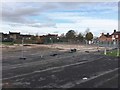
Knutton: site of former Recreation Centre
The Centre closed in 2012 when Newcastle's Jubilee 2 centre opened, and lay empty until it was demolished and the site cleared in November 2016.
Image: © Jonathan Hutchins
Taken: 16 Nov 2016
0.20 miles
7
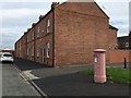
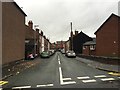
Knutton: Chapel Street
At first I thought the letterbox had been painted thus as part of Breast Cancer Awareness, but in fact it was simply an undercoat: by the evening it was again pillar-box red.
Image: © Jonathan Hutchins
Taken: 23 Sep 2015
0.21 miles
9
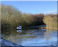
Flooding at the foot of Black Bank
Image: © Jonathan Hutchins
Taken: 22 Jan 2021
0.22 miles
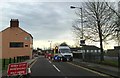
10
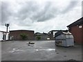
Newcastle Enterprise Centre
Beyond the fence at the far side is Knutton Recreation Centre.
Image: © Jonathan Hutchins
Taken: 21 May 2016
0.22 miles