IMAGES TAKEN NEAR TO
Eastcheap, RAYLEIGH, SS6 9JZ
Introduction
This page details the photographs taken nearby to Eastcheap, SS6 9JZ by members of the Geograph project.
The Geograph project started in 2005 with the aim of publishing, organising and preserving representative images for every square kilometre of Great Britain, Ireland and the Isle of Man.

There are currently over 7.5m images from over14,400 individuals and you can help contribute to the project by visiting https://www.geograph.org.uk
Image Map (Loading...)


Getting Data...Please wait
Leaflet Map data © OpenStreetMap
Images are licensed for reuse under creativecommons.org/licenses/by-sa/2.0
Notes
- Clicking on the map will re-center to the selected point.
- The higher the marker number, the further away the image location is from the centre of the postcode.
Image Listing (30 Images Found)
Images are licensed for reuse under creativecommons.org/licenses/by-sa/2.0
Image
Details
Distance
1
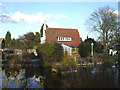
Willow Lodge
This large home, known as Willow Lodge, was built in 1932 for the Raven family, who owned a clothes shop in Southend. The lake in the garden at one time was home to a pair of Black Swans. The cul de sac next to the house is called Lakeside.
A developer is planning to knock the property down and build flats.
Image: © terry joyce
Taken: 21 Nov 2007
0.08 miles
2
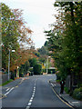
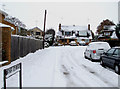
Down Hall Road, Rayleigh.
Down Hall Road is a very busy road as people from Hullbridge and the north of Rayleigh use it to get into Rayleigh.
Image: © terry joyce
Taken: 18 Oct 2010
0.12 miles
3
Deepdene Avenue
Taken from the junction of Image This view is looking towards the entrance of this road and the junction of Image
Image: © terry joyce
Taken: 1 Dec 2010
0.13 miles
4
Deepdene Avenue
Taken at the junction of Image, looking towards the end of the road, which is a no through road, however there is a useful pathway that leads to Image, which is near to one of the entrances to Sweyne Park.
Image: © terry joyce
Taken: 1 Dec 2010
0.14 miles
5

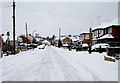
Down Hall Close
This close is accessed from Down Hall Road.
Image: © terry joyce
Taken: 13 Jan 2011
0.14 miles
6
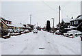
Dene Close
A very small Close, only a few properties, however there is a useful pathway that leads to Image and more importantly Image
Image: © terry joyce
Taken: 1 Dec 2010
0.14 miles
7
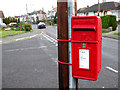
George VI Postbox
On the junction of Deepdene Avenue and Downhall Road.
George VI 1936-1952.
Image: © terry joyce
Taken: 22 Nov 2010
0.16 miles
8
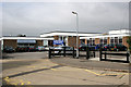
Down Hall Primary School
Down Hall Primary School, Brooklyn Drive entrance.
The School's postcode is SS6 9LW.
Image: © terry joyce
Taken: 12 Oct 2007
0.17 miles
9
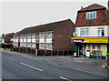
Down Hall Stores
A convenience store in Downhall Road.
Image: © terry joyce
Taken: 28 Oct 2010
0.17 miles
10
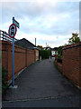
Shortest Bridleway
This is FP69 linking Canterbury Close and Deepdene Avenue. It is designated a Bridleway but is only around 20 metres long
Image: © terry joyce
Taken: 1 Nov 2012
0.17 miles