IMAGES TAKEN NEAR TO
Goggs Lane, SALISBURY, SP5 2NY
Introduction
This page details the photographs taken nearby to Goggs Lane, SP5 2NY by members of the Geograph project.
The Geograph project started in 2005 with the aim of publishing, organising and preserving representative images for every square kilometre of Great Britain, Ireland and the Isle of Man.

There are currently over 7.5m images from over14,400 individuals and you can help contribute to the project by visiting https://www.geograph.org.uk
Image Map (Loading...)


Getting Data...Please wait
Leaflet Map data © OpenStreetMap
Images are licensed for reuse under creativecommons.org/licenses/by-sa/2.0
Notes
- Clicking on the map will re-center to the selected point.
- The higher the marker number, the further away the image location is from the centre of the postcode.
Image Listing (6 Images Found)
Images are licensed for reuse under creativecommons.org/licenses/by-sa/2.0
Image
Details
Distance
1
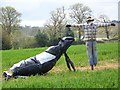
Scarecrow near Redlynch
Just one of the entrants in the Morgan's Vale and Woodfalls Primary School's Springfest.
Image: © Maigheach-gheal
Taken: 25 Apr 2010
0.20 miles

3
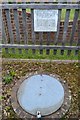
Quavey Well
The sign says that the well was dug in 1900 and was still in regular use until the early 1950s. It was last refurbished in 2004.
Image: © David Martin
Taken: 15 Jun 2018
0.23 miles