IMAGES TAKEN NEAR TO
Primrose Lane, SALISBURY, SP5 2NA
Introduction
This page details the photographs taken nearby to Primrose Lane, SP5 2NA by members of the Geograph project.
The Geograph project started in 2005 with the aim of publishing, organising and preserving representative images for every square kilometre of Great Britain, Ireland and the Isle of Man.

There are currently over 7.5m images from over14,400 individuals and you can help contribute to the project by visiting https://www.geograph.org.uk
Image Map (Loading...)


Getting Data...Please wait
Leaflet Map data © OpenStreetMap
Images are licensed for reuse under creativecommons.org/licenses/by-sa/2.0
Notes
- Clicking on the map will re-center to the selected point.
- The higher the marker number, the further away the image location is from the centre of the postcode.
Image Listing (16 Images Found)
Images are licensed for reuse under creativecommons.org/licenses/by-sa/2.0
Image
Details
Distance
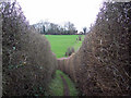
1
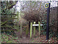
Footpath, Morgans Vale
The footpath takes walkers from Primrose Lane steeply downhill towards Woodfalls.
Image: © Maigheach-gheal
Taken: 15 Jan 2007
0.02 miles
2
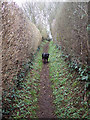
Hedged Footpath
Path from Primrose Lane, Morgan's Vale to Woodfalls.
Image: © Maigheach-gheal
Taken: 15 Jan 2007
0.02 miles
4
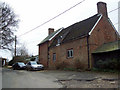
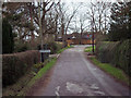
Days Farm, Primrose Lane, Morgan's Vale
Image: © Maigheach-gheal
Taken: 15 Jan 2007
0.03 miles
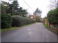
6
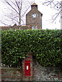
The Tower at Tower House with Post Box
Image: © Maigheach-gheal
Taken: 15 Jan 2007
0.08 miles
8
Primrose Lane to Woodfalls Footpath
The path continues uphill to the outskirts of Woodfalls.
Image: © Maigheach-gheal
Taken: 15 Jan 2007
0.11 miles
9
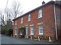
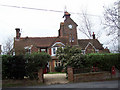
Red House, Morgan's Vale Road, Morgan's Vale
Image: © Maigheach-gheal
Taken: 15 Jan 2007
0.11 miles