IMAGES TAKEN NEAR TO
High Street, SALISBURY, SP3 4SB
Introduction
This page details the photographs taken nearby to High Street, SP3 4SB by members of the Geograph project.
The Geograph project started in 2005 with the aim of publishing, organising and preserving representative images for every square kilometre of Great Britain, Ireland and the Isle of Man.

There are currently over 7.5m images from over14,400 individuals and you can help contribute to the project by visiting https://www.geograph.org.uk
Image Map (Loading...)


Getting Data...Please wait
Leaflet Map data © OpenStreetMap
Images are licensed for reuse under creativecommons.org/licenses/by-sa/2.0
Notes
- Clicking on the map will re-center to the selected point.
- The higher the marker number, the further away the image location is from the centre of the postcode.
Image Listing (26 Images Found)
Images are licensed for reuse under creativecommons.org/licenses/by-sa/2.0
Image
Details
Distance
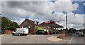
1
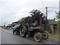
2016: a year on Geograph (Day 232)
Traction engine in Tilshead
Image: © Basher Eyre
Taken: 19 Aug 2016
0.02 miles
2
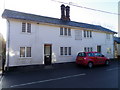
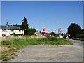
Flood Cottages, Tilshead
The cottages are built in 1842 of the plastered cob.
Cob has been used extensively for thousands of years. In Britain there is evidence of its use dating back to the C13th. It was used as a cheap and readily available building material, which required the minimum of tools, skills and knowledge to use.
Cob was the traditional method of earth wall construction. It developed in areas with poor building stone or limited timber supply. Its use was predominant in the south-western counties and parts of Hampshire. During the C19th. there was a surge in cob building as taxes prohibited the lower classes from building in brick.
However, towards the middle of the century when the taxes were repealed, cob
construction tailed off, and by the turn of the century very little new cob building was taking place.
A large cast-iron plaque, on wall in the centre of front first floor, commemorates the building of the cottages. For a close-up of the plaque Image
Image: © Maigheach-gheal
Taken: 12 Dec 2010
0.05 miles
3
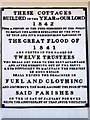
Plaque, Flood Cottages
The plaque records details of the 'Awful Visitation' that happened to Tilshead in 1841.
The Flood Cottages were built in 1842 from public fund to help the poor in the Tilshead and Shrewton parishes who had suffered in the Great Flood of 1841.
Special circumstances created the great flood. Two days after a heavy snowstorm there was a rapid thaw and at about five o'clock on 16th January a torrent of water several feet deep rushed down the valley over the still frozen ground that was unable to absorb it. It is said that the water was up to fifteen feet deep as it poured through the village, sweeping some cottages clean away and only leaving a wall or chimney stack standing of others. The damaged amounted to many thousands of pounds for besides houses, barns, walls fences and animals were destroyed.
Fortunately the people did have warning of the disaster and managed to escape the torrent.
Image: © Maigheach-gheal
Taken: 12 Dec 2010
0.05 miles
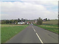
6
Tilshead from the Chitterne Road
Tilshead is effectively a garrison town dominated by the presence of Westdown Camp http://www.geograph.org.uk/photo/874193
Image: © Brian Robert Marshall
Taken: 19 Aug 2009
0.09 miles
8
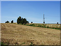
Field and bushes, Tilshead
The field has recently been harvested of its cereal crop. The bushes mark the edge of the A360 road from Salisbury to Devizes.
Image: © Brian Robert Marshall
Taken: 19 Aug 2009
0.14 miles
9
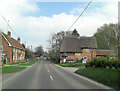
The High Street passes Elm Cottage
The thatched cottage to the right of the road is Grade II listed with English Heritage Building ID: 319892. It dates from the early 17th C.
Image: © Stuart Logan
Taken: 25 Apr 2013
0.16 miles
10
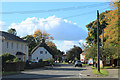
2012 : A360 High Street, Tilshead
Looking west from the village green.
Tilshead is located between the two parts of the military range and was lucky not to suffer the same fate as Imber.
Image: © Maurice Pullin
Taken: 14 Oct 2012
0.17 miles