IMAGES TAKEN NEAR TO
Clench Common, MARLBOROUGH, SN8 4NZ
Introduction
This page details the photographs taken nearby to SN8 4NZ by members of the Geograph project.
The Geograph project started in 2005 with the aim of publishing, organising and preserving representative images for every square kilometre of Great Britain, Ireland and the Isle of Man.

There are currently over 7.5m images from over14,400 individuals and you can help contribute to the project by visiting https://www.geograph.org.uk
Image Map (Loading...)


Getting Data...Please wait
Leaflet Map data © OpenStreetMap
Images are licensed for reuse under creativecommons.org/licenses/by-sa/2.0
Notes
- Clicking on the map will re-center to the selected point.
- The higher the marker number, the further away the image location is from the centre of the postcode.
Image Listing (8 Images Found)
Images are licensed for reuse under creativecommons.org/licenses/by-sa/2.0
Image
Details
Distance
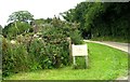
1
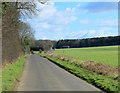
2012 : The only road on Clench Common
A minor road heading south east toward Wootton Rivers.
Image: © Maurice Pullin
Taken: 5 Mar 2012
0.06 miles
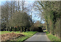
3

Cottages, Culley's Farm, Clench Common
Possible that this is Keeper's Cottage. The maps show this along with Culley's Farm Cottages, a reminder in their titles of the relationship between farmers and their workers.
Image: © Brian Robert Marshall
Taken: 24 Jul 2011
0.07 miles
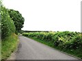
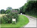
4
The road to Clench Common
The narrow rural road is viewed from the entrance to Culley's Farm.
Image: © Brian Robert Marshall
Taken: 24 Jul 2011
0.08 miles
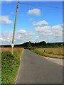
5
2012 : North west on Clench Common
A minor road crosses the common to join the A345 at Levetts Farm.
Image: © Maurice Pullin
Taken: 5 Mar 2012
0.09 miles
8
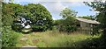
Overton Heath Farm
Abandoned farm buildings.
Image: © Oast House Archive
Taken: 1 Sep 2017
0.17 miles