IMAGES TAKEN NEAR TO
Grasmere, SWINDON, SN3 6LE
Introduction
This page details the photographs taken nearby to Grasmere, SN3 6LE by members of the Geograph project.
The Geograph project started in 2005 with the aim of publishing, organising and preserving representative images for every square kilometre of Great Britain, Ireland and the Isle of Man.

There are currently over 7.5m images from over14,400 individuals and you can help contribute to the project by visiting https://www.geograph.org.uk
Image Map (Loading...)


Getting Data...Please wait
Leaflet Map data © OpenStreetMap
Images are licensed for reuse under creativecommons.org/licenses/by-sa/2.0
Notes
- Clicking on the map will re-center to the selected point.
- The higher the marker number, the further away the image location is from the centre of the postcode.
Image Listing (24 Images Found)
Images are licensed for reuse under creativecommons.org/licenses/by-sa/2.0
Image
Details
Distance
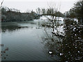
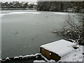
1
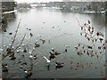
Liden Lagoon, Swindon (1)
The lagoon is, I believe, a flood storage facility built during the development of the South Dorcan Extension of the late 1960s to early 1980s. It provides a habitat for various water birds and a leisure resource. This a view to the north-east.
Image: © Brian Robert Marshall
Taken: 5 Feb 2009
0.13 miles
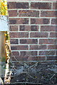
2
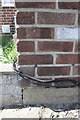
Benchmark on #6 Mackenzie
Ordnance Survey cut mark benchmark described on the Bench Mark Database at http://www.bench-marks.org.uk/bm66198
Image: © Roger Templeman
Taken: 22 Apr 2015
0.13 miles
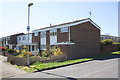
3
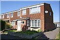
Houses on west side of Liden Drive
There is an OS benchmark Image on the right hand side of the near house at its front corner
Image: © Roger Templeman
Taken: 22 Apr 2015
0.14 miles
4
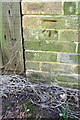
Benchmark on #6 Barrington Close
Ordnance Survey cut mark benchmark described on the Bench Mark Database at http://www.bench-marks.org.uk/bm66422
Image: © Roger Templeman
Taken: 22 Apr 2015
0.15 miles
5
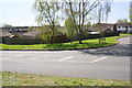
Junction of Barrington Close and Liden Drive
There is an OS benchmark Image on the outbuilding behind the road name sign
Image: © Roger Templeman
Taken: 22 Apr 2015
0.15 miles
6
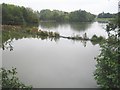
Swindon: Liden Lagoon
Liden Lagoon is, I think, a storm water balancing pond that was excavated in the 1960s, and allows a gradual release of water, particularly in a flood event, over a weir to the watercourse downstream. Artificial banks appear to have been recently constructed radiating out here from the northern of the two islands in the lagoon, visible here on the left.
Image: © Nigel Cox
Taken: 12 Oct 2007
0.15 miles
7
Liden Lagoon, Swindon (2)
The lagoon is, I believe, a flood storage facility built during the development of the South Dorcan Extension of the late 1960s to early 1980s. It provides a habitat for various water birds and a leisure resource. This a view to the south-east.
Image: © Brian Robert Marshall
Taken: 5 Feb 2009
0.16 miles
8
Houses on Conan Doyle Walk
There is an OS benchmark Image on the near corner of the porch of the near house
Image: © Roger Templeman
Taken: 22 Apr 2015
0.16 miles
9
Benchmark on porch of #1 Conan Doyle Walk
Ordnance Survey cut mark benchmark described on the Bench Mark Database at http://www.bench-marks.org.uk/bm66199
Image: © Roger Templeman
Taken: 22 Apr 2015
0.17 miles
10
Liden Lagoon, Swindon (4)
The lagoon is, I believe, a flood storage facility built during the development of the South Dorcan Extension of the late 1960s to early 1980s. It provides a habitat for various water birds and a leisure resource including coarse fishing. A local resident has placed birdfood on the fishing platform in the foreground. This a view to the north-west.
Image: © Brian Robert Marshall
Taken: 5 Feb 2009
0.17 miles