1
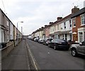
Rose Street
Early 20th Century terraced housing in Rose Street, seen from where it crosses Morris Street. The street was shown as laid out on the 1923 25 inch map, but with no development on this section.
Image: © Ian Capper
Taken: 14 Jul 2022
0.03 miles
2
Rose Street
The older parts of Rodbourne were laid out on a grid pattern, with mainly terraced housing. In recent years there has been much infilling and extension, with modern housing, some of which has been built on the sites of demolished buildings, or on former allotment land. Rose Street is typical in containing both old and new housing stock.
Image: © P L Chadwick
Taken: 5 Oct 2010
0.03 miles
3
Summers Street, Even Swindon, Swindon
Viewed from the Rodbourne Road end looking towards Morrison Street.
The Parish Church of St Augustine of Canterbury http://www.geograph.org.uk/photo/4388916 is on the right.
Image: © Jaggery
Taken: 15 Mar 2015
0.04 miles
4
Morrison Street
Turn of the 19th/20th Century terraced housing in Morrison Street, seen from where it crosses Morris Street. The street was shown as laid out on the 1900 25 inch map, but with no development on this section.
Image: © Ian Capper
Taken: 14 Jul 2022
0.06 miles
5
Looking NE along Hughes Street
Image: © Nick Smith
Taken: 28 Oct 2009
0.06 miles
6
Houses on Morrison Street at Hughes Street junction
#109 on the corner currently for sale
Image: © Roger Templeman
Taken: 15 Mar 2016
0.06 miles
7
Montagu Street
Early 20th Century terraced housing in Montagu Street, seen from where it crosses Morris Street. The street was first shown on the 1923 25 inch map.
Image: © Ian Capper
Taken: 14 Jul 2022
0.06 miles
8
Long row of parked cars, Summers Street, Even Swindon, Swindon
Double yellow lines keep the left side clear of cars, with one exception.
Image: © Jaggery
Taken: 15 Mar 2015
0.07 miles
9
Benchmark on #67 Montagu Street
Ordnance Survey cut mark benchmark described on the Bench Mark Database at http://www.bench-marks.org.uk/bm74261
Image: © Roger Templeman
Taken: 15 Mar 2016
0.08 miles
10
Houses at Morris Street / Montagu Street junction
There is an OS benchmark
Image on the corner, left hand face, of the nearest house
Image: © Roger Templeman
Taken: 15 Mar 2016
0.08 miles


