1
Melksham Police Station
A view looking south to the new Melksham police station, which is also a divisional headquarters of the Wiltshire Constabulary.
Image: © Phil Williams
Taken: 1 Mar 2006
0.03 miles
2
Melksham Police Station
A view looking southeast to the new Melksham police station.
Image: © Phil Williams
Taken: 1 Mar 2006
0.03 miles
3
2009 : The end of the road, except for permit holders
And joggers? Yes we can let him pass.
Semington Road, formerly the A350, now bypassed and closed to most traffic.
About half a mile from Semington village.
19.10.2012 : Buses as well.
Image: © Maurice Pullin
Taken: 6 Dec 2009
0.04 miles
4
House at Outmarsh
This is on the stretch of road shown in
Image, now closed off to vehicles to the north, except for buses.
Image: © Derek Harper
Taken: 20 Jul 2011
0.06 miles
5
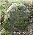
Old Milestone by Outmarsh, Melksham Without parish
Stone post (plate lost) by the UC road (was A350), in parish of Melksham Without (West Wiltshire District), Outmarsh; opposite Outmarsh Farm buildings, on bank behind ditch, on East side of road. Westbury plate, erected by the Westbury turnpike trust in the 19th century.
Inscription once read:-
(Melksham 1½)
(Westbury 7)
Milestone Society National ID: WI_WYMK07
Image: © M Faherty
Taken: 1 Jan 2008
0.08 miles
6
Wiltshire Air Ambulance station
Image: © Rob Purvis
Taken: 28 Jun 2024
0.10 miles
7
2009 : New trading estate near Outmarsh, Melksham
A flat, uninteresting area between Melksham and the K & A Canal at Semington. The ideal place to put a trading estate.
The roundabout is on Semington Road.
Image: © Maurice Pullin
Taken: 6 Dec 2009
0.12 miles
8
Wiltshire Air Ambulance headquarters
South of Melksham at Outmarsh, reached by road via Semington
Image: © Steve Roberts
Taken: 9 Jun 2020
0.13 miles
9
Entrance to Wiltshire Air Ambulance headquarters
Semington Road, Outmarsh, south of Melksham
Image: © Steve Roberts
Taken: 9 Jun 2020
0.13 miles
10
2009 : A gallimaufry of signs on Semington Road
Mostly advertising premises to let on a new industrial estate.
Image: © Maurice Pullin
Taken: 6 Dec 2009
0.16 miles


