1
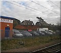
Site of "Silkingrad" railway station.
The proposal to build a new town at Stevenage was not well received by the locals. On the occasion of the visit to the site by the Minister for Town and Country Planning, Lewis Silkin, in the late 1940s, locals re-painted the sign on the railway station "Silkingrad" to greet him. The station is now further south in the heart of the new town at TL234240. The industrial units are typical railside industry trading in hardware, stationery, building materials, etc, etc.
Image: © Robin Hall
Taken: 1 Feb 2006
0.07 miles
2
Stevenage: looking towards the site of old station, East Coast main line 1992
View NW from Bridge Road bridge: ex-GNR London - Doncaster section of the ECML, electrified King's Cross - Hitchin 1976. The station was replaced 23/7/73 by an entirely new station ½-mile to the south.
Image: © Ben Brooksbank
Taken: 14 May 1992
0.10 miles
3
J & B Autos by the ECML
Image: © N Chadwick
Taken: 25 Feb 2011
0.10 miles
4
Stevenage: Site of the former Stevenage railway station
Before Stevenage New Town was built the original Stevenage railway station was here, on the south side of the Julian's Road bridge. Today this is the East Coast Main Line.
Image: © Nigel Cox
Taken: 21 Jan 2012
0.10 miles
5
Waiting on an East Coast train outside Stevenage alongside J&B Autos
Image: © Steve Fareham
Taken: 28 Nov 2011
0.11 miles
6
Stevenage railway station (site), Hertfordshire
Opened in 1850 by the Great Northern Railway on its line from London to Peterborough, this station survived until 1973 when it was replaced by a new one about a mile to the south, which is closer to the 'new' town. View north from passing train.
Image: © Nigel Thompson
Taken: 12 Feb 2011
0.11 miles
7
Stevenage: The Mallard
The pub sign features both the bird and the Gresley locomotive, a reflection that just off to the right is the East Coast Main Line railway and the location of Stevenage's original railway station before the New Town was built. The pub was then the Railway Inn.
Image: © Nigel Cox
Taken: 21 Jan 2012
0.13 miles
8
Trackside wild flowers
Waiting on the East Coast main line.
Image: © Steve Fareham
Taken: 18 Jun 2013
0.14 miles
9
Stevenage: The former Rising Sun public house
Now converted into residential accommodation the former Rising Sun in Julian's Road is just around the corner from
Image] and was also probably built to serve the passing trade to and from the old Stevenage railway station.
Image: © Nigel Cox
Taken: 21 Jan 2012
0.14 miles
10
Gunnels Wood Road, Stevenage
Crossing the railway line
Image: © David Howard
Taken: 28 Sep 2017
0.18 miles


