IMAGES TAKEN NEAR TO
Lower Road, LONDON, SE16 2XF
Introduction
This page details the photographs taken nearby to Lower Road, SE16 2XF by members of the Geograph project.
The Geograph project started in 2005 with the aim of publishing, organising and preserving representative images for every square kilometre of Great Britain, Ireland and the Isle of Man.

There are currently over 7.5m images from over14,400 individuals and you can help contribute to the project by visiting https://www.geograph.org.uk
Image Map (Loading...)


Getting Data...Please wait
Leaflet Map data © OpenStreetMap
Images are licensed for reuse under creativecommons.org/licenses/by-sa/2.0
Notes
- Clicking on the map will re-center to the selected point.
- The higher the marker number, the further away the image location is from the centre of the postcode.
Image Listing (311 Images Found)
Images are licensed for reuse under creativecommons.org/licenses/by-sa/2.0
Image
Details
Distance
1
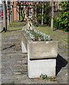
Cattle trough, Surrey Quays Road
Erected by the Metropolitan Drinking Fountain and Cattle Trough Association, probably c1890.
Image: © Stephen Richards
Taken: 26 May 2013
0.01 miles
2
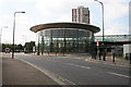
Canada Water station
Until a few years ago, there was no station here at all. Then when the Jubilee Line extension was planned, someone realised that it crossed the East London line at this point, so the bright idea was born to have a transport interchange here. So we got a new station serving both lines, and a bus station to boot. The handsome modern design outshines any other East London line station!
Image: © Dr Neil Clifton
Taken: 13 Sep 2007
0.02 miles
3

Canada Water transport interchange
Station entrance to two lines is on the right, with the bus station on the left. All new - all part of making London accessible without the car. This is the future.
Image: © Dr Neil Clifton
Taken: 13 Sep 2007
0.02 miles
4
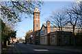
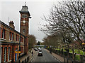
Dock Offices, Surrey Docks
The Surrey Docks were once very big business, and appropriately the management had these extensive offices built in the late Victorian years. The Surrey Docks have now been closed for many years, but the building has been used, inter alia, by the London Docklands Development Consortium. They have now moved out, and the splendid building is now for sale or lease. Let us hope that some worthy use can be found for it which will ensure its preservation for posterity. It is not a listed building but certainly should be.
Image: © Dr Neil Clifton
Taken: 14 Nov 2007
0.02 miles
5
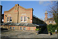
Dock Offices, Surrey Docks (2)
This is a rear view of the extensive offices of the former Surrey Docks. The high build quality can be seen.
Image: © Dr Neil Clifton
Taken: 14 Nov 2007
0.02 miles
6
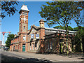
Surrey Quays Road by former dock offices
The former offices of the Surrey Commercial Dock Company, 1893, a grade II listed building.
Image: © Robin Webster
Taken: 6 Apr 2019
0.03 miles
7
Rotherhithe Police Station
Located on Lower Road close to the junction with Surrey Quays Road, the building's bright blue panels have faded badly.
Image: © Martin Addison
Taken: 22 Oct 2010
0.03 miles
8
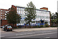
Surrey Docks offices
An office block on Surrey Quays Road. For a bit of its history see Image It was still "to let" three years later.
Image: © Stephen Craven
Taken: 22 May 2010
0.03 miles
9
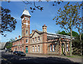
Former Dock Offices, Surrey Quays Road
Dating from 1892, two-tone brick with a conspicuous tower (Image]). Grade II listed.
Now offices.
Image: © Stephen Richards
Taken: 26 May 2013
0.03 miles
10
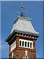
Detail of former Dock Offices, Surrey Quays Road
The tower has a fishscale slate roof and weathervane.
Full view: Image
Image: © Stephen Richards
Taken: 26 May 2013
0.03 miles