IMAGES TAKEN NEAR TO
Abercrave, SWANSEA, SA9 1XU
Introduction
This page details the photographs taken nearby to SA9 1XU by members of the Geograph project.
The Geograph project started in 2005 with the aim of publishing, organising and preserving representative images for every square kilometre of Great Britain, Ireland and the Isle of Man.

There are currently over 7.5m images from over14,400 individuals and you can help contribute to the project by visiting https://www.geograph.org.uk
Image Map (Loading...)


Getting Data...Please wait
Leaflet Map data © OpenStreetMap
Images are licensed for reuse under creativecommons.org/licenses/by-sa/2.0
Notes
- Clicking on the map will re-center to the selected point.
- The higher the marker number, the further away the image location is from the centre of the postcode.
Image Listing (2 Images Found)
Images are licensed for reuse under creativecommons.org/licenses/by-sa/2.0
Image
Details
Distance
1
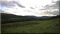
Land above Abercraf
This is typical of the land above Abercraf, much of it is left for sheep to graze on.
Image: © Helen
Taken: 26 Sep 2014
0.12 miles
2
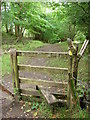
Stile on former tramroad incline
This mile long incline runs from above Pen Cribarth at around 350m down to School Road, Abercraf at below 150m. It is now a public footpath giving access from the village onto the Cribarth ridge.
Image: © Alan Bowring
Taken: 12 Sep 2008
0.22 miles