IMAGES TAKEN NEAR TO
Gaddarn Reach, MILFORD HAVEN, SA73 1PW
Introduction
This page details the photographs taken nearby to Gaddarn Reach, SA73 1PW by members of the Geograph project.
The Geograph project started in 2005 with the aim of publishing, organising and preserving representative images for every square kilometre of Great Britain, Ireland and the Isle of Man.

There are currently over 7.5m images from over14,400 individuals and you can help contribute to the project by visiting https://www.geograph.org.uk
Image Map (Loading...)


Getting Data...Please wait
Leaflet Map data © OpenStreetMap
Images are licensed for reuse under creativecommons.org/licenses/by-sa/2.0
Notes
- Clicking on the map will re-center to the selected point.
- The higher the marker number, the further away the image location is from the centre of the postcode.
Image Listing (21 Images Found)
Images are licensed for reuse under creativecommons.org/licenses/by-sa/2.0
Image
Details
Distance
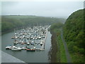
1
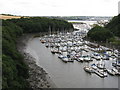
Westfield Pill
This small creek is crowded with vessels, forming Neyland Yacht Haven.
Image: © Stephen McKay
Taken: 21 Aug 2010
0.04 miles
2
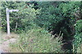
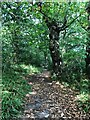
Path emerging from Neyland Wood
The Coast Path leaves the woodland on to Cambrian Road. The right hand arm of the post says, 'Pembroke Dock'.
Image: © M J Roscoe
Taken: 4 Jul 2023
0.06 miles
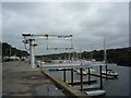
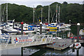
3
Neyland Marina
The marina viewed from the road bridge on a dismal rainy day.
Image: © Robin Lucas
Taken: 15 May 2009
0.07 miles
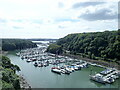
4
Westfield Pill
This creek of the Cleddau Estuary is occupied by Neyland Yacht Haven offering 420 sheltered berths.
Image: © Stephen McKay
Taken: 21 Aug 2010
0.09 miles
5
Marina At Neyland
On the northern side of the Milford Haven opposite Pembroke Dock.
Image: © Garth Newton
Taken: 18 Jul 2003
0.11 miles
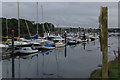
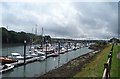
6
Upper and Lower basins of Neyland Marina
Viewed from the bridge that crosses Westfield Pill
Image: © Eirian Evans
Taken: 31 Aug 2022
0.12 miles
7
The Pembrokeshire Coast Path near Great Honeyborough
Image: © Dave Kelly
Taken: 9 May 2017
0.12 miles
8
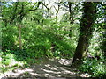
Neyland Wood
The Pembrokeshire Coast Path winding through Neyland Wood heading towards the Cleddau Bridge. The woods stretch for about half a mile along the west side of Westfield Pill
Image: © Eirian Evans
Taken: 31 Aug 2022
0.14 miles