IMAGES TAKEN NEAR TO
Clasemont Road, SWANSEA, SA6 6AJ
Introduction
This page details the photographs taken nearby to Clasemont Road, SA6 6AJ by members of the Geograph project.
The Geograph project started in 2005 with the aim of publishing, organising and preserving representative images for every square kilometre of Great Britain, Ireland and the Isle of Man.

There are currently over 7.5m images from over14,400 individuals and you can help contribute to the project by visiting https://www.geograph.org.uk
Image Map (Loading...)


Getting Data...Please wait
Leaflet Map data © OpenStreetMap
Images are licensed for reuse under creativecommons.org/licenses/by-sa/2.0
Notes
- Clicking on the map will re-center to the selected point.
- The higher the marker number, the further away the image location is from the centre of the postcode.
Image Listing (9 Images Found)
Images are licensed for reuse under creativecommons.org/licenses/by-sa/2.0
Image
Details
Distance
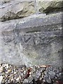
1
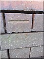
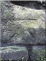
Ordnance Survey Cut Mark
This OS cut mark can be found on the wall of Llwyneryr Unit, to the west of Clasemont Road. It marks a point 79.437m above mean sea level.
Image: © Adrian Dust
Taken: 6 Feb 2014
0.05 miles
2
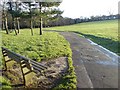
Morriston Park
A small space of green in the centre of Morriston.
Image: © Hywel Williams
Taken: 16 Dec 2006
0.09 miles
3
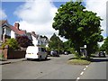
Bus shelter and service road, Clasemont Road, Morriston
Image: © David Smith
Taken: 2 Jun 2018
0.10 miles
4
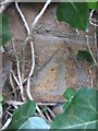
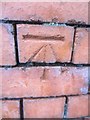
Ordnance Survey Cut Mark
This OS cut mark can be found on the wall to the NE of Clasemont Road. It marks a point 94.647m above mean sea level.
Image: © Adrian Dust
Taken: 6 Feb 2014
0.13 miles
5
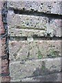
Ordnance Survey Cut Mark
This OS cut mark can be found on the wall to the south of the Pentrepoeth Road & Vicarage Road. It marks a point 71.591m above mean sea level.
Image: © Adrian Dust
Taken: 6 Feb 2014
0.15 miles
6
Ordnance Survey Cut Mark
This OS cut mark can be found on the wall of No173 Vicarage Road. It marks a point 70.589m above mean sea level.
Image: © Adrian Dust
Taken: 6 Feb 2014
0.18 miles
7
Ordnance Survey Cut Mark
This OS cut mark can be found on the wall between No93 & No95 Pentrepoeth Road. It marks a point 64.389m above mean sea level.
Image: © Adrian Dust
Taken: 6 Feb 2014
0.22 miles
8
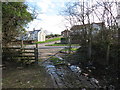
Llwybr Treforus / Morriston Footpath
Llwybr cyhoeddus yn cyrraedd yr A48 yn Nhreforus.
A public footpath meeting the A48 in Morriston.
Image: © Alan Richards
Taken: 7 Mar 2014
0.22 miles
9
Ordnance Survey Cut Mark
This OS cut mark can be found on the front of No106 Vicarage Road. It marks a point 68.699m above mean sea level.
Image: © Adrian Dust
Taken: 6 Feb 2014
0.24 miles