IMAGES TAKEN NEAR TO
Llys Y Felin, KIDWELLY, SA17 4UQ
Introduction
This page details the photographs taken nearby to Llys Y Felin, SA17 4UQ by members of the Geograph project.
The Geograph project started in 2005 with the aim of publishing, organising and preserving representative images for every square kilometre of Great Britain, Ireland and the Isle of Man.

There are currently over 7.5m images from over14,400 individuals and you can help contribute to the project by visiting https://www.geograph.org.uk
Image Map (Loading...)


Getting Data...Please wait
Leaflet Map data © OpenStreetMap
Images are licensed for reuse under creativecommons.org/licenses/by-sa/2.0
Notes
- Clicking on the map will re-center to the selected point.
- The higher the marker number, the further away the image location is from the centre of the postcode.
Image Listing (46 Images Found)
Images are licensed for reuse under creativecommons.org/licenses/by-sa/2.0
Image
Details
Distance
1

Station Road house construction site, Kidwelly
Viewed in March 2013.
Image: © Jaggery
Taken: 29 Mar 2013
0.08 miles
2
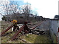
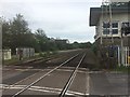
Siding near Kidwelly railway station
The buffers are at the edge of the level crossing adjacent to Kidwelly railway station,
opposite the signal box.
Image: © Jaggery
Taken: 29 Mar 2013
0.08 miles
4
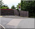
STOP when lights show sign, Station Road, Kidwelly
The sign on the corner of Station Road and Llys y Foryd is on the approach to this http://www.geograph.org.uk/photo/3394665 level crossing.
Image: © Jaggery
Taken: 16 Jul 2015
0.10 miles
5
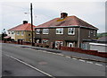
Station Road semis, Kidwelly
Four semi-detached houses set slightly below road level.
Image: © Jaggery
Taken: 16 Jul 2015
0.10 miles
6
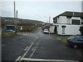
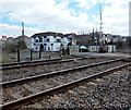
Signal box and railway
Level crossing, and signal box on the railway at Kidwelly.
Image: © Alan Hughes
Taken: 1 Jun 2019
0.10 miles
7
Across the tracks, Kidwelly railway station
Viewed from this http://www.geograph.org.uk/photo/3394739 path looking towards Anthony's Hotel. http://www.geograph.org.uk/photo/3394137
Image: © Jaggery
Taken: 29 Mar 2013
0.11 miles
8
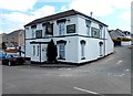
Anthony's Hotel, Kidwelly
On the corner of Station Road and Hillfield Villas, a few metres from the level crossing adjacent to Kidwelly railway station.
Image: © Jaggery
Taken: 29 Mar 2013
0.11 miles
9
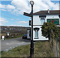
Quay Road signpost, Kidwelly
The black cat depicted on top of the post is similar to the one depicted on the town's boundary sign. http://www.geograph.org.uk/photo/3387051 The origin of the association of a black cat with Kidwelly is obscure. One version is that a black cat was the first creature seen alive after a great plague hit the town. It was therefore honoured as a symbol of salvation and deliverance and subsequently used as Kidwelly's heraldic symbol.
Image: © Jaggery
Taken: 29 Mar 2013
0.11 miles
10
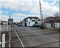
Road across a level crossing, Kidwelly
The level crossing is at the edge of Kidwelly railway station. http://www.geograph.org.uk/photo/3394748
Quay Road behind the camera becomes Hillfield Villas on the left side
of Anthony's Hotel http://www.geograph.org.uk/photo/3394137 and Station Road on the right side.
Image: © Jaggery
Taken: 29 Mar 2013
0.11 miles