1
Extra large plant pot at Hollins Lane
Image: © John H Darch
Taken: 3 Jul 2012
0.10 miles
2
The New Holly Inn at Forton
Image: © Ian Greig
Taken: 9 Oct 2015
0.11 miles
3
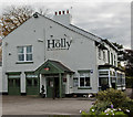
The Holly
The Holly alongside the A6.
Image: © Peter McDermott
Taken: 8 Oct 2016
0.11 miles
4
The New Holly Inn, Preston Lancaster Road, Forton
New in the 19C. It faces the early 19C turnpike road, whereas the Bay Horse Inn is on the old road. The Old Holly Inn (Hamilton Arms) is 1km south in Cabus.
Image: © Humphrey Bolton
Taken: 13 May 2007
0.12 miles
5
I dare you
Derestriction signs might be tempting to some!
Image: © David Long
Taken: 1 Jan 2006
0.17 miles
6
London to Glasgow Railway Line
Looking south towards Preston from Cleveley Bridge
Image: © Alexander P Kapp
Taken: 13 Nov 2007
0.17 miles
7
The West Coast Main Line
Looking south this is the West Coast main line from Glasgow To London Euston as seen from Cleveley road bridge looking towards Preston just before dusk.
Image: © roger geach
Taken: 18 Mar 2009
0.18 miles
8
Old Milestone by the A6, entrance to Holly Bank, Forton parish
Metal plates attached to stone post by the A6, in parish of FORTON (WYRE District), Forton, in front of hedge, on West side of road, by entrance drive to Holly Bank. Lancaster twin iron plate, erected by the Garstang & Heronsyke turnpike trust in the 19th century.
Inscription reads:-
: LANCASTER / VII / MILES : : FORTON : : GARSTANG / III¾ / MILES :
Milestone Society National ID: LA_LAGS07.
Image: © C Marcus
Taken: Unknown
0.18 miles
9
Field with trees, Threshers Court
Image: © Peter Bond
Taken: 4 Feb 2011
0.21 miles
10
Hollins Hill Post Office, Forton
Or former post office? It is identified by the post-box built into the wall, but doesn't have the familiar red oval sign.
Image: © Humphrey Bolton
Taken: 13 May 2007
0.21 miles


