IMAGES TAKEN NEAR TO
Central Treviscoe, ST. AUSTELL, PL26 7QW
Introduction
This page details the photographs taken nearby to PL26 7QW by members of the Geograph project.
The Geograph project started in 2005 with the aim of publishing, organising and preserving representative images for every square kilometre of Great Britain, Ireland and the Isle of Man.

There are currently over 7.5m images from over14,400 individuals and you can help contribute to the project by visiting https://www.geograph.org.uk
Image Map (Loading...)


Getting Data...Please wait
Leaflet Map data © OpenStreetMap
Images are licensed for reuse under creativecommons.org/licenses/by-sa/2.0
Notes
- Clicking on the map will re-center to the selected point.
- The higher the marker number, the further away the image location is from the centre of the postcode.
Image Listing (7 Images Found)
Images are licensed for reuse under creativecommons.org/licenses/by-sa/2.0
Image
Details
Distance
1
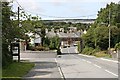
Treviscoe
Treviscoe is a village in the middle of the china clay workings. The bridge over the road carries the mineral railway.
Image: © Tony Atkin
Taken: 26 Aug 2006
0.06 miles
2
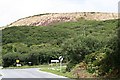
China Clay Waste Tip near Treviscoe
The lower terrace is wooded, the upper terrace appears to be supporting some heathers and there is some recent tree planting.
Image: © Tony Atkin
Taken: 26 Aug 2006
0.06 miles
3
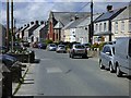
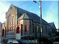
Treviscoe, St Stephen-in-Brannel
The main road through Treviscoe with its Methodist chapel prominent.
Image: © Andrew Smith
Taken: 9 May 2019
0.13 miles
6
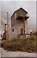
Parkandillack Engine House
Photographed in 1980.
Image: © Ian Hodkinson
Taken: 4 Aug 1980
0.22 miles
7
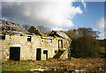
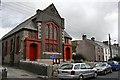
St Dennis: derelict barns at Treviscoe Barton
Beyond one of the barns an overshot waterwheel survived in its wheelpit in 1998
Image: © Martin Bodman
Taken: Unknown
0.25 miles