IMAGES TAKEN NEAR TO
Trekenner, LAUNCESTON, PL15 9PN
Introduction
This page details the photographs taken nearby to PL15 9PN by members of the Geograph project.
The Geograph project started in 2005 with the aim of publishing, organising and preserving representative images for every square kilometre of Great Britain, Ireland and the Isle of Man.

There are currently over 7.5m images from over14,400 individuals and you can help contribute to the project by visiting https://www.geograph.org.uk
Image Map (Loading...)


Getting Data...Please wait
Leaflet Map data © OpenStreetMap
Images are licensed for reuse under creativecommons.org/licenses/by-sa/2.0
Notes
- Clicking on the map will re-center to the selected point.
- The higher the marker number, the further away the image location is from the centre of the postcode.
Image Listing (18 Images Found)
Images are licensed for reuse under creativecommons.org/licenses/by-sa/2.0
Image
Details
Distance
1
Trekenner Mill
The lane from Image runs straight across the Inny flood plain to the mill, on a leat at the foot of the northern valley slope. Part of the mill, reputedly on this site since the C11, is shown more clearly in Image
Image: © Derek Harper
Taken: 4 Mar 2015
0.00 miles
2
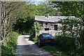
Trekenner Mill
This old mill house in the floor of the Inny Valley and is home to a green funeral directors business.
Image: © Tony Atkin
Taken: 5 May 2007
0.01 miles
3
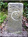
Old Boundary Marker
County Bridge Marker on the southeast side of the minor road north of Trekenner Bridge, River Inny. Lezant parish. Inscribed C. The stone marks the extent of roadway adjoining the bridge that the County was obliged to maintain.
Milestone Society National ID: CW_LEZ03br
Image: © R Hanns
Taken: 27 Dec 2019
0.02 miles
4
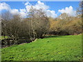
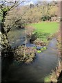
Inny at Trekenner Mill
Looking upstream, with riverside trees and a meadow.
Image: © Derek Harper
Taken: 4 Mar 2015
0.03 miles
5
Inny at Trekenner Mill
Looking upstream from the bridge shown in Image; the River Inny is on the left. On the right, running parallel to the lane from the bridge to the mill, but flowing the opposite way, is a side channel of the leat, presumably an overflow from the mill pool. One of the buildings at the mill is in the background; see also Image
Image: © Derek Harper
Taken: 4 Mar 2015
0.03 miles
6
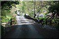
Trekenner Bridge
This is an old single lane bridge over the River Inny.
Image: © Tony Atkin
Taken: 5 May 2007
0.04 miles
7
Trekenner Bridge
This is looking out of the woodland over the slightly humped bridge to the old mill house on the other side of the flood plain.
Image: © Tony Atkin
Taken: 5 May 2007
0.04 miles
8
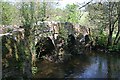
Trekenner Bridge
The view is also shown in Image; this is a couple of motnsh earlier in the year, hence fewer leaves. The centre of the bridge is in Image but this side is across a gridline in Image The packhorse bridge across the River Inny is "probably C16 with minor later repairs" http://list.historicengland.org.uk/resultsingle.aspx?uid=1291058&searchtype=mapsearch . In the background is Trekenner Mill.
Image: © Derek Harper
Taken: 4 Mar 2015
0.04 miles
9
Trekenner Bridge
The upstream side of the packhorse bridge across the Inny; Image shows the downstream side. See http://list.historicengland.org.uk/resultsingle.aspx?uid=1291058&searchtype=mapsearch . As with Image], in the background is Trekenner Mill.
Image: © Derek Harper
Taken: 4 Mar 2015
0.04 miles
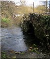
10

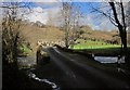
Track near Trekenner Bridge
With a ford in the foreground, and seen from the lane from Bray Shop. On the left is Quarryhill Wood.
Image: © Derek Harper
Taken: 4 Mar 2015
0.10 miles