IMAGES TAKEN NEAR TO
Fionnphort, ISLE OF MULL, PA66 6BW
Introduction
This page details the photographs taken nearby to PA66 6BW by members of the Geograph project.
The Geograph project started in 2005 with the aim of publishing, organising and preserving representative images for every square kilometre of Great Britain, Ireland and the Isle of Man.

There are currently over 7.5m images from over14,400 individuals and you can help contribute to the project by visiting https://www.geograph.org.uk
Image Map (12 Images)


Getting Data...Please wait
Leaflet Map data © OpenStreetMap
Images are licensed for reuse under creativecommons.org/licenses/by-sa/2.0
Notes
- Clicking on the map will re-center to the selected point.
- The higher the marker number, the further away the image location is from the centre of the postcode.
Image Listing (12 Images Found)
Images are licensed for reuse under creativecommons.org/licenses/by-sa/2.0
Image
Details
Distance
1
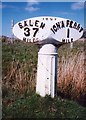
Old Milepost by the A849, Aridhglas, Isle of Mull
Blaydon casting milepost by the A849, in parish of Kilfinichen and Kilvickeon (Mull District), Aridhglas, on verge.
Inscription reads:-
: SALEN / 37 / MILES : : 1897 : : IONA FERRY / 1 / MILE :
Maker:-
: SMITH PATTERSON / FOUNDERS / BLAYDON :
Surveyed
Milestone Society National ID: AB_MLSAIF37
Image: © Milestone Society
Taken: Unknown
0.04 miles
2

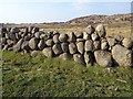
Dry stone wall, Aridhglas
Made of rounded rocks, a wonder it stays up
Image: © Eirian Evans
Taken: 16 Sep 2020
0.08 miles
3
Wall of boulders alongside A849
The boulder wall is immediately on the south side of the A849, east of Fionnphort.
Image: © Trevor Littlewood
Taken: 23 Apr 2015
0.11 miles
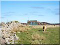
4
Ruin by Aridhglas
A small ruined house by Aridhglas with the war memorial in the background.
Image: © Andrew Wood
Taken: 30 Aug 2018
0.13 miles
5
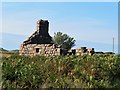
Ruined Cottage
A ruined cottage by Aridhglas.
Image: © Andrew Wood
Taken: 31 Aug 2018
0.14 miles
6
Drystane dyke, Airighglas
Beside the A849. The technique, also common in the Mourne granite area of Co. Down, exploits the superb friction of the granite. The rocks are just stacked.
Image: © Richard Webb
Taken: 8 Apr 2019
0.16 miles
7
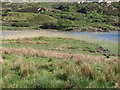
Reed Bed
Reed beds occur at the north East, and north west of this loch
Image: © Mrs V Bryant
Taken: 24 May 2008
0.17 miles
8
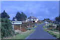
Approaching the junction for Kintra
On the A849.
Image: © Andrew Abbott
Taken: 5 Oct 2021
0.18 miles
9
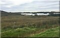
Loch Poit na h-I
The northern end of the loch with three little islets
Image: © Eirian Evans
Taken: 16 Sep 2020
0.18 miles
10
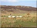
Grazing, Airighglas
Ross of Mull grazings.
Image: © Richard Webb
Taken: 8 Apr 2019
0.20 miles