IMAGES TAKEN NEAR TO
Trident Way, RENFREW, PA4 0LJ

Introduction

This page details the photographs taken nearby to Trident Way, PA4 0LJ by members of the Geograph project.

The Geograph project started in 2005 with the aim of publishing, organising and preserving representative images for every square kilometre of Great Britain, Ireland and the Isle of Man.

There are currently over 7.5m images from over14,400 individuals and you can help contribute to the project by visiting https://www.geograph.org.uk

Image Map


Images are licensed for reuse under creativecommons.org/licenses/by-sa/2.0
Notes
  • Clicking on the map will re-center to the selected point.
  • The higher the marker number, the further away the image location is from the centre of the postcode.

Image Listing (25 Images Found)

Images are licensed for reuse under creativecommons.org/licenses/by-sa/2.0
  • ...
Image
Details
Distance
1
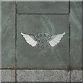
SAAS Memorial: kerb detail
The detail is in the southeastern part of the kerb that was added during the 2016 site improvement. That side is on the near right in Image and the near left in Image An inscription on the northeastern side says: "This site was improved in 2016 by Renfrewshire Council with support from Renfrew Community Council, Renfrew and Gallowhill Local Area Committee and Glasgow Airport's FlightPath Fund". Aside from that, various place-names and other pieces of text are incorporated into the kerb using different sizes of font: Islay, Benbecula, Orkney, Skye, Campbeltown, Machrihanish, Harris, Tiree, "1933—1966", Colonsay, Coll, North Uist, Shetland, South Uist, Barra, Arran.
Image: © Lairich Rig Taken: 19 May 2018
0.01 miles
2
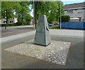
Scottish Air Ambulance Service Memorial
This picture was taken after the 2016 improvement of the site. See Image for more context.
Image: © Lairich Rig Taken: 19 May 2018
0.01 miles
3
Scottish Air Ambulance Service Memorial
The present picture was taken after the 2016 improvement of the site; see Image for an equivalent earlier view.
Image: © Lairich Rig Taken: 19 May 2018
0.01 miles
4
Scottish Air Ambulance Service Memorial
Image: © Lairich Rig Taken: 19 May 2018
0.01 miles
5
Scottish Air Ambulance Service Memorial
I found that the site of the memorial had been improved since my last visit: compare Image, the corresponding earlier view (2014).
Image: © Lairich Rig Taken: 19 May 2018
0.01 miles
6
Scottish Air Ambulance Service Memorial
See Image for more about the memorial, and click on the end-note title for other views. I had previously visited the memorial in November 2014, but returned on this occasion to take a picture when the lighting conditions were less bleak. It was, though, in a shaded spot, and sunshine would not have improved the view of it. The site was, though, improved in 2016: see Image for an equivalent later picture.
Image: © Lairich Rig Taken: 31 Aug 2015
0.01 miles
7
Scottish Air Ambulance Service Memorial
For a close look at the other side of the memorial, and the inscription on it, see Image; for that side, in context, see Image For a view similar to the present one, but with better lighting, see Image In the present view, Newmains Road is receding on the right, and Sandy Road crosses from left to right. The picture shows that there is also an inscription on this side. It reads as follows: "This cairn also pays homage to the memory of the following members of the Service who lost their lives at Islay when answering a call for help on 28th September, 1957. Captain T M Calderwood Radio Officer H McGinlay Nursing Sister J Kennedy 'The names of those who in their lives fought for life, Who wore at their hearts the fire's centre. Born of the sun, they travelled a short while towards the sun And left the vivid air signed with their honour' –Stephen Spender"
Image: © Lairich Rig Taken: 3 Nov 2014
0.01 miles
8
Scottish Air Ambulance Service Memorial
For a closer look, and for the inscription on this side, see Image [Note that the setting was improved in 2016: Image is an equivalent later view.] The present photograph is intended mainly to provide context for the closer view, showing the memorial in its setting at the junction of Sandy Road and Newmains Road. In the present view, Newmains Road is in the background. For the other side of the memorial, and the inscription there, see Image (As with most things of interest, I came across the memorial randomly, but its location is marked on large-scale OS mapping.)
Image: © Lairich Rig Taken: 3 Nov 2014
0.01 miles
9
Scottish Air Ambulance Service Memorial
The memorial's location is marked on large-scale OS mapping. In this view, Newmains Road is in the background. The inscription on this side is as follows: "This cairn is erected by the Town Council of the Royal Burgh of Renfrew as a tribute to the men and women of the Scottish Air Ambulance Service who operated from Renfrew Airport in all possible weather conditions from 1933 until the airport closed on 30th April 1966, and who, by their courage, skill and selfless devotion to duty, drove the fear of serious illness from the islands. The plinth on which the cairn stands contains stones from the islands and other places which these gallant airmen and nurses served so faithfully." For a view of this side of the memorial in context, see Image There is also an inscription on the other side of the memorial; for a view of that side, and for the text of its inscription, see Image
Image: © Lairich Rig Taken: 3 Nov 2014
0.01 miles
10
Sandy Road, Renfrew
From the corner of St Andrews Road.
Image: © Stephen Sweeney Taken: 7 Aug 2007
0.04 miles
  • ...