IMAGES TAKEN NEAR TO
Holloway Road, WITNEY, OX28 6NH
Introduction
This page details the photographs taken nearby to Holloway Road, OX28 6NH by members of the Geograph project.
The Geograph project started in 2005 with the aim of publishing, organising and preserving representative images for every square kilometre of Great Britain, Ireland and the Isle of Man.

There are currently over 7.5m images from over14,400 individuals and you can help contribute to the project by visiting https://www.geograph.org.uk
Image Map (Loading...)


Getting Data...Please wait
Leaflet Map data © OpenStreetMap
Images are licensed for reuse under creativecommons.org/licenses/by-sa/2.0
Notes
- Clicking on the map will re-center to the selected point.
- The higher the marker number, the further away the image location is from the centre of the postcode.
Image Listing (126 Images Found)
Images are licensed for reuse under creativecommons.org/licenses/by-sa/2.0
Image
Details
Distance
2

Witney fire station
Witney fire station, Welch Way, Witney, Oxfordshire
Image: © Kevin Hale
Taken: 5 Oct 2007
0.06 miles

5

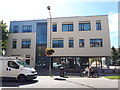
Witney College
Part of the new campus at the Witney site of the dual location Abingdon and Witney College. http://www.abingdon-witney.ac.uk/
Image: © Des Blenkinsopp
Taken: 15 Apr 2012
0.10 miles
6
Abingdon and Witney College on GCSE results day, 2020
Image: © Vieve Forward
Taken: 20 Aug 2020
0.10 miles
7
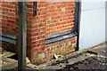
Benchmark on the Thames Water Pumping Station, Dark Lane
Ordnance Survey cut mark benchmark described on the Bench Mark Database at http://www.bench-marks.org.uk/bm37212
Image: © Roger Templeman
Taken: 5 Mar 2011
0.12 miles
8
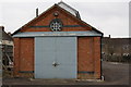
Thames Water Witney Pumping Station, Dark Lane
Photo taken from Moor Avenue. The Ordnance Survey benchmark on the corner to the left of the doors is shown at Image
Image: © Roger Templeman
Taken: 5 Mar 2011
0.12 miles
9
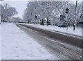
Welch Way
Welch Way and Witney Community Hospital in the background.
Image: © Miranda Hodgson
Taken: 6 Jan 2010
0.12 miles
10
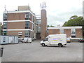
Witney Telephone Exchange, Oxon
Situated off Welch Way, this TE dates from the mid-1960s replacing the former Manual TE in the town. It has the code SMWI and provides telephone and broadband services to 12,841 residential and 961 non-residential premises in Witney plus Crawley, Curbridge, Ducklington, Hailey, Minster Lovell and South Leigh nearby. Mobile phone aerials can be seen on the roof of this TE, whilst BT Openreach vans are parked in front of it. It is perhaps unfortunate that this TE doesn't have a more prepossessing appearance for an old market town. The postcode of this TE is OX28 6JP.
Image: © David Hillas
Taken: 9 Jun 2015
0.13 miles