1
Jericho
Showing the Great Clarendon Street/Albert Street junction. Jericho, an area of tightly packed Victorian terraced housing (interspersed with the occasional more modern building) sandwiched between Walton Street and the Oxford Canal, was originally named after a local pub - although it is sometimes said that it was so-called because the houses were jerry built. Although originally a working class district, its proximity to central Oxford has meant inevitable gentrification.
Image: © Stephen McKay
Taken: 4 Jul 2007
0.01 miles
2
Cardigan Street at the junction of Albert Street
Image: © David Howard
Taken: 21 Feb 2016
0.02 miles
3
Cardigan Street, Jericho, Oxford
Viewed across Canal Street looking along Cardigan Street towards Albert Street.
Jericho St Barnabas Community Centre http://www.geograph.org.uk/photo/4088879 is on the right.
Image: © Jaggery
Taken: 31 Mar 2013
0.02 miles
4
Cardigan Street
This small group of terraced houses caught my eye with their pattern of grey bricks. They are located close to the junction with Hart Street, which is visible on the left of the photo.
Image: © Martin Addison
Taken: 11 Aug 2010
0.04 miles
5
Jericho
Looking along Canal Street from the junction with Cardigan Street. The building on the left is the Jericho St Barnabas Community Centre.
Image: © Stephen McKay
Taken: 4 Jul 2007
0.04 miles
6
Great Clarendon Street, Jericho
A nice example of a Citroen DS which has been kept like new
Image: © David Howard
Taken: 21 Feb 2016
0.04 miles
7
Jericho
Looking along Great Clarendon Street, one of the principal thoroughfares of the Jericho district.
Image: © Stephen McKay
Taken: 4 Jul 2007
0.04 miles
8
Old Bookbinders
A Greene King public house on the corner of Victor Street and Canal Street. A fitting name perhaps - given the proximity of The Oxford University Press on Walton Street. This public house appeared in the first television Inspector Morse episode, The Dead of Jericho.
Image: © Martin Addison
Taken: 11 Aug 2010
0.04 miles
9
Jericho Street and Albert Street, Jericho
The Jericho district of Oxford, with its tidy terraced houses, has become a fashionable suburb among young professionals - named among the top 20 'hip' locations in the country. It was not always so; in the 1960s the 19th century houses were in a rundown condition and there were proposals for comprehensive redevelopment which was avoided only by a concerted campaign to save Jericho. In this view, looking from Jericho Street across Albert Street into Victor Street, the tower of St Barnabas Church looks over the rooftops.
Image: © Stephen McKay
Taken: 11 Jul 2020
0.05 miles
10
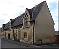
School Court, Jericho, Oxford
Houses in a converted former school, viewed across Great Clarendon Street.
Image: © Jaggery
Taken: 31 Mar 2013
0.05 miles


