1
Withington Road, Bicester
This view of Withington Road shows the main pedestrian route back up to northern Bicester from the town centre. The railway in the background is the Chiltern line serving Bicester North station, which divides the town in two halves. The amusingly named Crumps Butts is the narrow side lane to the left here.
Image: © Kurt C
Taken: 2 Feb 2009
0.09 miles
2
'Town Walk' Foot/Cycle Path
This picture is the view NE up the main walkway and cyclepath joining Withington Road (and the Town Centre) to the north side of Bicester (via a small short tunnel underneath railway). It is fully fenced off in both directions and on both sides, and is approx 300 yards long. Although it has existed for many years, it has recently been named 'Town Walk', though many locals are indifferent to its name!
Image: © Kurt C
Taken: 2 Feb 2009
0.10 miles
3
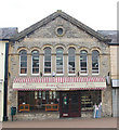
Former United Methodist Free Church, Bicester
Built 1863, taken over by the Wesleyans about 40 years later, and renamed Wesley Hall (still just to be made out on the elevation), and currently in use as a home furnishings shop.
Image: © Jim Osley
Taken: 5 May 2010
0.11 miles
4
Bicester, Victoria Road
1968 Ordnance Survey cut mark benchmark on the wall junction at the rear of the Penny Black pub showing its age. The bricks carrying the cut are eroded, and although the datum cut remains clear, the arrow cuts have more or less disappeared. The mark was levelled at 72.6674m above Newlyn datum. For more information about this and other nearby marks see http://www.bench-marks.org.uk/bm33914.
Image: © Roger Templeman
Taken: 28 Apr 2010
0.11 miles
5
Side view of Bicester Methodist Church (1)
This side view in Bell Lane shows a cross built into the red brickwork of this church. It is named after the Revd Grainger Hargreaves who was an early
Christian missionary in China, and the Methodist Minister from 1921 to 1923. The white double doors seen in the photo lead into the church hall behind the church.
Image: © David Hillas
Taken: 2 Sep 2021
0.11 miles
6
Side view of Bicester Methodist Church (2)
Taken in Bell Lane, this photo shows the redbrick church hall behind the church. Victoria Road can just be seen to the left of the photo.
Image: © David Hillas
Taken: 2 Sep 2021
0.11 miles
7
The Bell, Sheep St
Image: © Robert Eva
Taken: 23 Mar 2017
0.13 miles
8
Sheep Street, Bicester 3
Looking north-west near the Penny Black, see
Image
Fleetingly in sunshine on this autumnal morning.
Image: © Jonathan Billinger
Taken: 1 Oct 2008
0.13 miles
9
Bicester Methodist church
Image: © Robert Eva
Taken: 23 Mar 2017
0.13 miles
10
The Angel pub sign, 102 Sheep Street
The sign looks fairly new but the building is believed to date from the 1600's, and the pub has been known by other names in the past.
Image: © P L Chadwick
Taken: 12 Jun 2008
0.13 miles


