IMAGES TAKEN NEAR TO
Mongewell Park, WALLINGFORD, OX10 8DA
Introduction
This page details the photographs taken nearby to Mongewell Park, OX10 8DA by members of the Geograph project.
The Geograph project started in 2005 with the aim of publishing, organising and preserving representative images for every square kilometre of Great Britain, Ireland and the Isle of Man.

There are currently over 7.5m images from over14,400 individuals and you can help contribute to the project by visiting https://www.geograph.org.uk
Image Map (Loading...)


Getting Data...Please wait
Leaflet Map data © OpenStreetMap
Images are licensed for reuse under creativecommons.org/licenses/by-sa/2.0
Notes
- Clicking on the map will re-center to the selected point.
- The higher the marker number, the further away the image location is from the centre of the postcode.
Image Listing (216 Images Found)
Images are licensed for reuse under creativecommons.org/licenses/by-sa/2.0
Image
Details
Distance
1
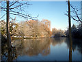
Mongewell Lake
This spring fed lake is the source of a very short Thames tributary. From the far end of the lake to confluence with the river can't be more than 600 metres, but in that short distance it takes in two lakes, a couple of waterfalls and a boathouse.
Image: © Des Blenkinsopp
Taken: 6 Jan 2010
0.04 miles
2
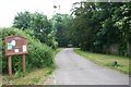
Road from the entrance
This road leads to the entrance gates on the main Reading road.
Image: © Bill Nicholls
Taken: 8 Jun 2008
0.05 miles
3
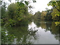
The Lake, Mongewell
Passed by the Ridgeway National Trail on its journey through Mongewell Park.
Image: © Chris Heaton
Taken: 2 Oct 2007
0.06 miles
4

Field beside the footpath
This is the pastureland that is beside the path from Mongewell park
Image: © Bill Nicholls
Taken: 8 Jun 2008
0.06 miles
5
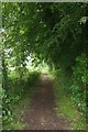
Straight bridleway
I must admit the bridleway is unusually straight here.
Image: © Bill Nicholls
Taken: 8 Jun 2008
0.07 miles
6
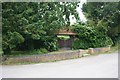
Lych gate on the corner
Actually the entrance to lych gate house.
Image: © Bill Nicholls
Taken: 8 Jun 2008
0.07 miles
7

Sunken footpath
This looks like a ditch and runs beside the bridle way but on reading about Mongewell park in Wikipedia it seems that one of the owners had the footpath sunk so he did not have to see the parishioners walking to church. Could this be the old footpath, certainly looks that way with the wall to the right and a high bank above it.
Image: © Bill Nicholls
Taken: 8 Jun 2008
0.07 miles
8
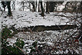
Sunken Pathway
One of past owners of Mongewell park used to be an atheist and so he did not have to watch the local people walking to Church he sank the footpath. This looks to be the remains of it along with a wall that runs along side.
Image: © Bill Nicholls
Taken: 13 Jan 2010
0.08 miles
9
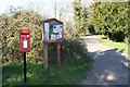
Post box on the corner
The postbox for Mongewell on the corner of the access road to the park.
Image: © Bill Nicholls
Taken: 29 Mar 2009
0.08 miles
10
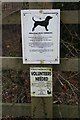
Volunteers needed
Couple of notices on the fence by the ridgeway path, the bottom one is for volunteers to help keep the ridgeway in good order.
Image: © Bill Nicholls
Taken: 31 Jan 2009
0.09 miles