IMAGES TAKEN NEAR TO
Clegg Hall Road, ROCHDALE, OL16 2QR
Introduction
This page details the photographs taken nearby to Clegg Hall Road, OL16 2QR by members of the Geograph project.
The Geograph project started in 2005 with the aim of publishing, organising and preserving representative images for every square kilometre of Great Britain, Ireland and the Isle of Man.

There are currently over 7.5m images from over14,400 individuals and you can help contribute to the project by visiting https://www.geograph.org.uk
Image Map (Loading...)


Getting Data...Please wait
Leaflet Map data © OpenStreetMap
Images are licensed for reuse under creativecommons.org/licenses/by-sa/2.0
Notes
- Clicking on the map will re-center to the selected point.
- The higher the marker number, the further away the image location is from the centre of the postcode.
Image Listing (15 Images Found)
Images are licensed for reuse under creativecommons.org/licenses/by-sa/2.0
Image
Details
Distance
1
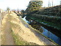
Rochdale Canal SW of Smithy Bridge
View NE of the canal and towpath towards Clegg Hall, currently undergoing restoration work but just outside this grid square. Photograph taken from above the towpath at SD919142.
Image: © michael ely
Taken: 19 Nov 2005
0.07 miles
2
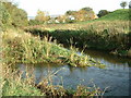
River Beal meets River Roch
Confluence of the River Beal with the River Roch at Belfield. From here the Roch continues to the centre of Rochdale.
Image: © Paul Hogg
Taken: Unknown
0.09 miles
3
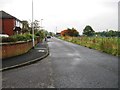
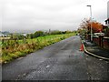
A rural landscape near Clover Hall
A more rural aspect soon emerges once Rochdale's suburbs are left behind.
Image: © Peter Whatley
Taken: 25 Mar 2011
0.09 miles
7
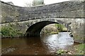
Clegg Hall Road bridge, Smallbridge
Early 19th century stone bridge over the River Roch, Listed Grade II. The quality of the bridge indicates that the road it carries, now a mere track, must have been a more important link at the time than it is now.
Image: © Alan Murray-Rust
Taken: 8 Apr 2022
0.18 miles
8
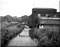
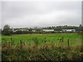
River Roch near Smallbridge, Lancashire
Looking east in 1973. The mill is Riverside Mill, which was a small cotton mill. Further away in the far left background is Dobwheel Mill.
Image: © Dr Neil Clifton
Taken: 3 Sep 1973
0.18 miles
9
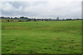
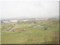
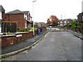
Fields by Clegg Hall Road
In the distance is the Clover Hall housing estate, and further away the top of Rochdale Town Hall.
Image: © Bill Boaden
Taken: 25 Aug 2012
0.19 miles