1
Rochdale: The 'Corporation Inn', Lower Tweedale Street
Like the 'Queens' across the other side of Milkstone Road, the 'Corporation' is closed, almost certainly permanently. Within this grid square, five public houses have now closed since Geograph began: only the 'Weavers Arms' on Ashfield Road still soldiers on. For reference the closures are: 'Navigation', 'Woolpack', 'Queens', 'Commercial', and 'Brown Cow'. This is really getting to crisis proportions!
Image: © Dr Neil Clifton
Taken: 18 Mar 2011
0.03 miles
2
Rochdale - Nye Bevan House
An NHS facility set back from Maclure Street.
Image: © Peter Whatley
Taken: 16 Sep 2009
0.04 miles
3
Rochdale: The 'Queens', Tweedale Street
When I first photographed the 'Queens', I got a First Geograph point for it. The 'Queens' was then still open. There are now some 90 images for this gridsquare, and the pub. is closed, probably permanently.
Image: © Dr Neil Clifton
Taken: 18 Mar 2011
0.04 miles
4
Corporation Inn, Milkstone Road, Rochdale
Image: © Ian S
Taken: 15 Nov 2019
0.05 miles
5
Rochdale rooftops
Viewed from Rochdale Railway Station.
Image: © SMJ
Taken: 23 Apr 2009
0.05 miles
6
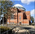
Church of St John the Baptist, Rochdale
A Roman Catholic church with a distinctive dome in the 'Byzantine' (Greek Orthodox) style. Built 1925-7, architect Ernest Bower Norris. Grade 2* listed (list entry 1376506).
Image: © Stephen Craven
Taken: 26 Nov 2018
0.06 miles
7
Metrolink disruption at Rochdale station
To enable Metrolink trams to run between Rochdale station and the town centre, the roundabout outside the station has been erased and station access drastically curtailed. Whether this and other, very costly works (e.g.: http://www.geograph.org.uk/photo/2238930 ) are worthwhile compared to simple bus shuttle, time will tell.
Image: © Peter Whatley
Taken: 19 Jan 2011
0.06 miles
8
Rochdale Station Metrolink tramstop
Image: © John Slater
Taken: 18 Oct 2014
0.07 miles
9
St John the Baptist R C Church
Dowling Street, Rochdale
Image: © David Dixon
Taken: 15 Mar 2010
0.07 miles
10
St John the Baptist's Roman Catholic Church
St John the Baptist Roman Catholic Church was founded in 1839 but rebuilt in a Byzantine style with a large dome in the manner of Hagia Sophia to a design by Oswald Hill (pre 1917) and executed in 1925-7 by Ernest Bower Norris. It is Grade II listed https://historicengland.org.uk/listing/the-list/list-entry/1376506
Image: © Gerald England
Taken: 22 Sep 2016
0.07 miles


