1
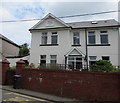
Former Garndiffaith Police Station
The plaque on the house on the east side of Herbert's Road in Garndiffaith shows POLICE STATION 1910.
Image: © Jaggery
Taken: 16 Jul 2018
0.01 miles
2
Hanbury Arms, Garndiffaith
Image: © Alex McGregor
Taken: 9 Jun 2010
0.01 miles
3
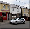
Family Grill House, 18 Herbert's Road, Garndiffaith
The takeaway (pizzas, kebabs, burgers, fried chicken) offers a home delivery service.
Image: © Jaggery
Taken: 16 Jul 2018
0.02 miles
4
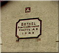
1849 tablet on the wall of Bethel Methodist Church, Garndiffaith
The tablet on the wall here https://www.geograph.org.uk/photo/5844207 shows that the church was Bethel Primitive Methodist Chapel when built in 1849. In 2018 it is Bethel Methodist Church. https://www.geograph.org.uk/photo/5844223
Image: © Jaggery
Taken: 16 Jul 2018
0.02 miles
5
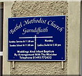
Information board on the wall of Bethel Methodist Church Garndiffaith
On display here https://www.geograph.org.uk/photo/5844207 in July 2018.
Image: © Jaggery
Taken: 16 Jul 2018
0.02 miles
6
Bethel Methodist Church, Herbert's Road, Garndiffaith
In 2018 the church is part of the Gwent Hills and Vales Methodist Circuit.
The tablet https://www.geograph.org.uk/photo/5844235 on the church wall shows BETHEL PRIMITIVE METHODIST CHAPEL A.D. 1849.
Image: © Jaggery
Taken: 16 Jul 2018
0.02 miles
7
Row of houses near Bethel Methodist Church, Garndiffaith
The church https://www.geograph.org.uk/photo/5844207 is on the right.
Image: © Jaggery
Taken: 16 Jul 2018
0.02 miles
8
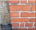
Ordnance Survey Cut Mark
This OS cut mark can be found on the wall of the old Police Station, Herberts Road. It marks a point 287.676m above mean sea level.
Image: © Adrian Dust
Taken: 25 Aug 2019
0.02 miles
9
Bethel Court, Garndiffaith
Image: © Alex McGregor
Taken: 9 Jun 2010
0.03 miles
10
Unnamed side road in Garndiffaith
Ascending from Herbert's Road towards The Avenue and Gelli Rhwy Road.
Image: © Jaggery
Taken: 16 Jul 2018
0.03 miles


