1
Southern entrance to Croesyceiliog School, Cwmbran
The Caernarvon Crescent entrance to Croesyceiliog School.
Image: © Jaggery
Taken: 11 Feb 2010
0.03 miles
2
Worcester Close, Llanyrafon, Cwmbran
Viewed from Caernarvon Crescent.
Image: © Jaggery
Taken: 11 Feb 2010
0.04 miles
3
Dorstone Walk, Llanyravon, Cwmbran
Dorstone Walk descends from Llanyravon Way towards Manorbier Drive.
Image: © Jaggery
Taken: 12 Apr 2017
0.09 miles
4
The Pastures, Llanyrafon, Cwmbran
Houses on the west side of The Pastures, viewed from the corner of Caernarvon Crescent.
Image: © Jaggery
Taken: 11 Feb 2010
0.09 miles
5
Caernarvon Crescent, Llanyrafon, Cwmbran
Looking along the northern end of Caernarvon Crescent as it heads away from Llanyrafon Way.
Image: © Jaggery
Taken: 11 Feb 2010
0.09 miles
6
Bilingual name sign facing Llanyravon Way, Llanyravon, Cwmbran
Located in a gap in a hedge here, http://www.geograph.org.uk/photo/5346896 the sign shows that Dorstone Walk is Tro Tref Y Cernyw in Welsh.
Image: © Jaggery
Taken: 12 Apr 2017
0.11 miles
7
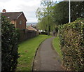
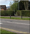
Toward a path beyond a gap in the hedge, Llanyravon, Cwmbran
Viewed across Llanyravon Way. The path http://www.geograph.org.uk/photo/5346887 is Dorstone Walk.
Image: © Jaggery
Taken: 12 Apr 2017
0.11 miles
8
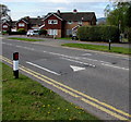
Llanyravon Way speed bumps, Llanyravon, Cwmbran
The bumps across Llanyravon Way are in a 20mph maximum speed zone near a primary school.
Image: © Jaggery
Taken: 12 Apr 2017
0.11 miles
9
Junction of Caernarvon Crescent and Llanyravon Way, Llanyravon, Cwmbran
This is one of two junctions of these roads in Llanyravon. The other one is 450 metres to the southwest.
The bilingual name sign on the right suggests that Caernarvon Crescent was named before Caernarfon became the usual spelling in English. The Welsh name shown is Cilgant Caernarfon.
Image: © Jaggery
Taken: 12 Apr 2017
0.11 miles
10
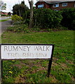
Rumney Walk/Tro Rhymni name sign Cwmbran
The English/Welsh sign faces Llanyravon Way at the western end of Rumney Walk. http://www.geograph.org.uk/photo/5397386
Image: © Jaggery
Taken: 12 Apr 2017
0.13 miles


