1
Springfield Close, Croesyceiliog
From the junction with Newport Road.
Image: © Jaggery
Taken: 8 Oct 2009
0.02 miles
2
Lay-by on the A4042(T)
Image: © John Lord
Taken: 12 Feb 2010
0.07 miles
3
Pontrhydyrun Baptist Church (Evangelical) information boards, Cwmbran
Outside this https://www.geograph.org.uk/photo/7678145 Grade II Listed church.
In December 2023 the board on the right shows that Sunday Services begin at 11am.
Image: © Jaggery
Taken: 24 Dec 2023
0.07 miles
4
Green in Newport Road, now a cul-de-sac, Croesyceiliog
Image: © Ruth Sharville
Taken: 12 Mar 2012
0.07 miles
5
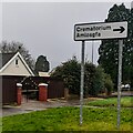
Bilingual Crematorium direction sign, Chapel Lane, Cwmbran
Crematorium is Amlosgfa in Welsh.
Image: © Jaggery
Taken: 24 Dec 2023
0.07 miles
6
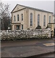
Grade II Listed Pontrhydyrun Baptist Church, Cwmbran
Grade II Listed in 1951 as "a particularly fine classical
chapel of 1836, of unusual size and with good ashlar detail".
Image: © Jaggery
Taken: 24 Dec 2023
0.08 miles
7
Mormon church, Croesyceiliog
Located on Newport Road, close to the junction with The Highway and Chapel Lane.
Though often referred to as Mormons, this religious group refer to themselves as the Church of Jesus Christ of Latter-day Saints.
Image: © Jaggery
Taken: 8 Oct 2009
0.08 miles
8
Ordnance Survey Cut Mark
This OS cut mark can be found on the east angle of the chapel. It marks a point 105.183m above mean sea level.
Image: © Adrian Dust
Taken: 16 Feb 2021
0.08 miles
9
Croesyceiliog Bypass
The A4042 heading south from the roundabout near Gwent Crematorium, viewed from the small grassy triangle where pedestrians cross the road.
Image: © Jaggery
Taken: 8 Oct 2009
0.08 miles
10
Chapel Lane, Croesyceiliog
Looking along Chapel Lane from the junction of The Highway and Newport Road. On the left is the turning for Cefn Close.
Image: © Jaggery
Taken: 8 Oct 2009
0.09 miles


