1
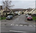
Maesgwyn, Cwmbran
Maesgwyn is a cul-de-sac ascending from the northwest side of Five Locks Road.
Image: © Jaggery
Taken: 6 Mar 2019
0.04 miles
2
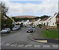
Maesgwyn, Pontnewydd, Cwmbran
Viewed from Five Locks Road.
Image: © Jaggery
Taken: 17 Oct 2009
0.04 miles
3
Track above Five Locks Road, Cwmbran
Above the south side of Five Locks Road near the Meadowbrook Avenue junction.
Image: © Jaggery
Taken: 6 Mar 2019
0.06 miles
4
Snow Scene at Five Locks, Pontnewydd
Looking north up the Monmouthshire & Brecon Canal during the snowfall of February 2009.
Image: © Matthew Lane
Taken: 5 Feb 2009
0.06 miles
5
Former canal north of Five Locks Road, Cwmbran
The disused Monmouthshire & Brecon canal, viewed from the edge of a former lock,
now a stepped cascade. http://www.geograph.org.uk/photo/1156826 to a winter view.
Image: © Jaggery
Taken: 26 Mar 2011
0.06 miles
6
Canalside houses, Five Locks, Cwmbran
The houses are located on the east side of Five Locks Close, alongside the disused Monmouthshire & Brecon canal.
Image: © Jaggery
Taken: 26 Mar 2011
0.06 miles
7
Former canal towpath, Five Locks, Cwmbran
The towpath, now a cycle way and footpath, heads north away from Five Locks Road along the east side of the disused Monmouthshire & Brecon canal. The canal bank is lined with a row of small metal posts formerly used for mooring barges.
Image: © Jaggery
Taken: 26 Mar 2011
0.06 miles
8
Small inlet on disused canal, Five Locks, Cwmbran
The inlet on the disused Monmouthshire & Brecon canal is adjacent to houses in Five Locks Close.
Image: © Jaggery
Taken: 26 Mar 2011
0.06 miles
9
Canal towpath north of Five Locks Road, Cwmbran
The towpath (now a cycle route and footpath) along the disused Monmouthshire & Brecon canal resumes on the north side of Five Locks Road. The road sign at the lower left edge shows Greenfield Close and Five Locks Close.
Image: © Jaggery
Taken: 26 Mar 2011
0.06 miles
10
Surface water on Five Locks Road, Cwmbran
Viewed at 4pm on March 6th 2019 after many hours of rain
the previous night which continued into the morning.
Alun the allosaurus https://www.geograph.org.uk/photo/6081874 is in the background.
Image: © Jaggery
Taken: 6 Mar 2019
0.07 miles


