1
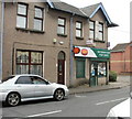
Liswerry Post Office, Newport
Post Office on the corner of Somerton Road and Kitty Hawk Drive.
Image: © Jaggery
Taken: 24 Sep 2009
0.03 miles
2
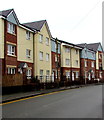
Kitty Hawk Drive, Newport
Viewed from the corner of Somerton Road, Kitty Hawk Drive is the connecting road through an area of modern houses with aviation-themed street names, such as Amy Johnson Close and Bleriot Close.
Image: © Jaggery
Taken: 24 Sep 2009
0.03 miles
3
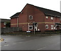
Fenced-off site of the former King pub, Somerton, Newport
Viewed across Somerton Road in February 2016.
This was the location of the King pub, seen here http://www.geograph.org.uk/photo/1504590 in September 2009.
Image: © Jaggery
Taken: 16 Feb 2016
0.03 miles
4
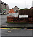
JCDecaux advertising hoardings, Somerton Road, Newport
Viewed across Somerton Road. Frobisher Road is on the left.
JCDecaux is the largest outdoor advertising corporation in the world.
Image: © Jaggery
Taken: 16 Feb 2016
0.03 miles
5
This way to Frobisher Gardens, Newport
In February 2016, the arrow on a notice on the corner of Somerton Road
points along Frobisher Road towards this http://www.geograph.org.uk/photo/4830168 house construction site.
Image: © Jaggery
Taken: 16 Feb 2016
0.04 miles
6
21st century housing, Somerton Road, Newport
Viewed in March 2020. The site was formerly occupied by the King pub seen here https://www.geograph.org.uk/photo/1504590 awaiting demolition in 2009.
Image: © Jaggery
Taken: 5 Mar 2020
0.04 miles
7
Corner of Kitty Hawk Drive and Somerton Road, Liswerry, Newport
The Kitty Hawk Drive name sign shows that the road on the left is not a through route.
Image: © Jaggery
Taken: 5 Mar 2020
0.04 miles
8
Corner of Frobisher Road and Somerton Road, Newport
The name sign shows that Frobisher Road leads to Blake Road.
Image: © Jaggery
Taken: 5 Mar 2020
0.04 miles
9
Kitty Hawk Drive, Liswerry, Newport
Looking south across Somerton Road in March 2020.
The Kitty Hawk Drive name signs show that the road ahead is not a through route.
Image: © Jaggery
Taken: 5 Mar 2020
0.05 miles
10
Shaz Snax, Newport
Sandwich bar at 68 Somerton Road, near the corner of Downing Street.
Image: © Jaggery
Taken: 16 Feb 2016
0.05 miles


