IMAGES TAKEN NEAR TO
Broadgate, NOTTINGHAM, NG9 2FU
Introduction
This page details the photographs taken nearby to Broadgate, NG9 2FU by members of the Geograph project.
The Geograph project started in 2005 with the aim of publishing, organising and preserving representative images for every square kilometre of Great Britain, Ireland and the Isle of Man.

There are currently over 7.5m images from over14,400 individuals and you can help contribute to the project by visiting https://www.geograph.org.uk
Image Map (Loading...)


Getting Data...Please wait
Leaflet Map data © OpenStreetMap
Images are licensed for reuse under creativecommons.org/licenses/by-sa/2.0
Notes
- Clicking on the map will re-center to the selected point.
- The higher the marker number, the further away the image location is from the centre of the postcode.
Image Listing (321 Images Found)
Images are licensed for reuse under creativecommons.org/licenses/by-sa/2.0
Image
Details
Distance
5
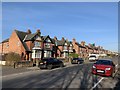
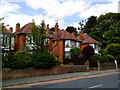
Peveril Road, Beeston
Semi detached houses on the south west side of Peveril Road starting with number 1.
Image: © Andrew Abbott
Taken: 25 Mar 2020
0.04 miles
6
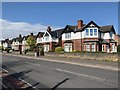
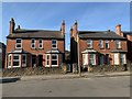
27-39 Broadgate and 1a Peveril Road, Beeston
Four pairs of semi-detached houses.
Image: © Andrew Abbott
Taken: 19 Apr 2020
0.05 miles
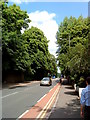
7
Junction of Broadgate and Broadgate Avenue
Image: © Andrew Abbott
Taken: 12 Jun 2010
0.06 miles
8
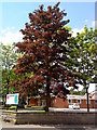
Beech tree outside the Beeston Free Church
Image: © Andrew Abbott
Taken: 12 Jun 2010
0.06 miles
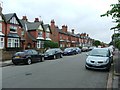
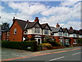
9
9-15 Peveril Road, Beeston
Ada Villas and Herbert Villas dating from 1914.
Image: © Andrew Abbott
Taken: 25 Mar 2020
0.06 miles
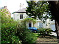
10
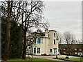
Broadgate House, Beeston
Grade II listed. Listing number 1248267. Formerly Beeston Observatory.
Image: © Andrew Abbott
Taken: 22 Jan 2023
0.07 miles