1
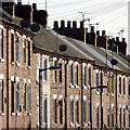
Sunshine on the terrace
Looking along Silk Street.
Image: © Alan Murray-Rust
Taken: 5 Dec 2014
0.01 miles
2
Lindley's Windmill, Sutton-in-Ashfield
Stone-built tower mill, built c.1823 by James Lindley to replace an earlier post mill destroyed by a gale in 1818. It was worked until 1895 after which it gradually became ruinous http://www.geograph.org.uk/photo/4274087. The structure has been consolidated in recent years and re-roofed, and the intention is to create educational displays. It can be visited by appointment, but when I turned up, the caretaker appeared from an adjacent house and was pleased to show me around. Listed Grade II.
Image: © Alan Murray-Rust
Taken: 5 Dec 2014
0.05 miles
3
Welcome to Lindley's Windmill, Sutton-in-Ashfield
Information board with an old picture of the mill with some features still remaining. It clearly had 4 sails and a fantail cap. There is a second information board at the site detailing the location of all 9 former mills - wind and water - in Sutton-in-Ashfield. This is the only survivor.
Image: © Alan Murray-Rust
Taken: 5 Dec 2014
0.05 miles
4
Sutton-in-Ashfield - St Josephs Social Club
On High Pavement.
Image: © Dave Bevis
Taken: 7 Feb 2013
0.07 miles
5
Government Offices in Sutton in Ashfield
Former government offices built in the brutalist / modernist style. Empty at the date of posting although a refurbishment is planned.
Image: © Jonathan Clitheroe
Taken: 5 Jan 2019
0.10 miles
6
Coming soon, fully refurbished offices
Marked on OS maps as Govt Offs, but no indication of which department they were occupied by.
Image: © Alan Murray-Rust
Taken: 5 Dec 2014
0.11 miles
7
Sutton-in-Ashfield - Devonshire Arms
Image: © Dave Bevis
Taken: 7 Feb 2013
0.11 miles
8
Sutton-in-Ashfield - United Reformed Church
This church was opened on April 4th 1906. The architects of the building were G. Baines & Son of London and the builders were J. Greenwood's of Mansfield.
Mainly because of the unusual nature of the pews inside, it is a Grade II Listed Building. See http://www.ashfield-dc.gov.uk/ccm/navigation/community-and-living/faiths--beliefs-and-religions/sutton-united-reformed-church/ .
Image: © Dave Bevis
Taken: 1 Apr 2013
0.12 miles
9
Sutton-in-Ashfield - United Reformed Church
On High Pavement. For another view and more information, please see
Image
Image: © Dave Bevis
Taken: 24 Feb 2015
0.12 miles
10
Sutton-in-Ashfield United Reformed Church, High Pavement
Built in 1905 as a Congregational church, designed by G Baines & Son of London in a free Gothic style favoured at the time. Listed Grade II.
Image: © Alan Murray-Rust
Taken: 5 Dec 2014
0.13 miles


