1
Nottingham - NG1
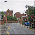
This view along Bluecoat Close, a cul-de-sac running parallel with Mansfield Road (A60), draws the eye in the direction of a new construction being built on the horizon just beyond the YMCA's city centre building on Shakespeare Street.
Image: © David Hallam-Jones
Taken: 21 Apr 2012
0.02 miles
2
Former Newcastle Arms, North Sherwood Street
Image: © SK53
Taken: 1 Apr 2013
0.03 miles
3
Mansfield Road
Taken to show the distinct change in style and quality on either side of the road junction.
One of a series showing different building styles on Mansfield Road. See http://www.geograph.org.uk/search.php?i=5550541
Image: © Alan Murray-Rust
Taken: 8 Mar 2009
0.03 miles
4
Newcastle Arms, Nottingham
Image: © Chris Whippet
Taken: 28 Jul 2015
0.03 miles
5
Up Bluecoat Close
The tall building to the left is the former Bluecoat School. The building in the centre middle distance is a many-windowed former lace or hosiery works. Apart from the bright rowan berries, colours were muted on a damp September morning.
Image: © John Sutton
Taken: 11 Sep 2018
0.03 miles
6
Refreshment room at the rear of the former Judge's bakery
The rear of the building described in this view https://www.geograph.org.uk/photo/6225183 .
The refreshment room was added in c.1900, with an unusual clerestory roof and elaborate stained glass windows. Listed Grade II.
Image: © Alan Murray-Rust
Taken: 12 Aug 2019
0.04 miles
7
Former C W Judge bakery, Mansfield Road, Nottingham
See http://www.geograph.org.uk/photo/6225183 for location. The original shop front of c.1860 survives intact.
Image: © Alan Murray-Rust
Taken: 26 Jul 2019
0.04 miles
8
Mansfield Road on a wet morning
Encounters Restaurant occupies a former baker's shop, C W Judge. Cars are waiting at the Woodborough Road lights.
Image: © John Sutton
Taken: 11 Sep 2018
0.04 miles
9
Shops on Mansfield Road
This particular group have their shop fronts set forward from the rest of the buildings.
One of a series showing different building styles on Mansfield Road. See http://www.geograph.org.uk/search.php?i=5550541
Image: © Alan Murray-Rust
Taken: 8 Mar 2009
0.04 miles
10
YMCA International Community Centre, Nottingham
Formerly, until 1967, the Nottingham Bluecoat School http://list.english-heritage.org.uk/resultsingle.aspx?uid=1270611&searchtype=mapsearch . It dates from 1852. Note the rock footing to the wall in the foreground.
Image: © Derek Harper
Taken: 12 Oct 2014
0.04 miles


