IMAGES TAKEN NEAR TO
Headlam Green, NEWCASTLE UPON TYNE, NE6 2NZ
Introduction
This page details the photographs taken nearby to Headlam Green, NE6 2NZ by members of the Geograph project.
The Geograph project started in 2005 with the aim of publishing, organising and preserving representative images for every square kilometre of Great Britain, Ireland and the Isle of Man.

There are currently over 7.5m images from over14,400 individuals and you can help contribute to the project by visiting https://www.geograph.org.uk
Image Map (Loading...)


Getting Data...Please wait
Leaflet Map data © OpenStreetMap
Images are licensed for reuse under creativecommons.org/licenses/by-sa/2.0
Notes
- Clicking on the map will re-center to the selected point.
- The higher the marker number, the further away the image location is from the centre of the postcode.
Image Listing (60 Images Found)
Images are licensed for reuse under creativecommons.org/licenses/by-sa/2.0
Image
Details
Distance
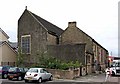
1
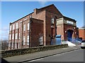
Byker Community Association Building, Headlam Street
Image: © Andrew Curtis
Taken: 28 Mar 2010
0.03 miles
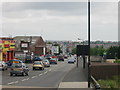
2
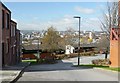
The view from Avondale Road, Byker
The Tyne bridges, the Baltic and the Sage can be seen to the left. Central Newcastle and St James' Park stadium are to the right, the latter above the wedge of nearby, Tom Collins House.
Image: © Andrew Curtis
Taken: 28 Mar 2010
0.03 miles
3
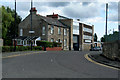
Welbeck Road
Welbeck Road in Byker.
Image: © Peter McDermott
Taken: 23 Aug 2008
0.03 miles
6
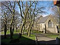
St Michael's Church, Byker
The church has been closed for several years and the surrounding area has been heavily vandalised. The neighbouring vicarage building was demolished for safety reasons. St Michael's Mount, on which the church stands, is a beautiful setting though, with a stand of mature trees, and views down to the Tyne and the Millennium Bridge.
Image: © Andrew Curtis
Taken: 28 Mar 2010
0.06 miles
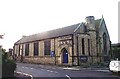
7
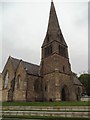
The Church of St Michael with St Lawrence, Byker
Image: © Bill Henderson
Taken: 11 Jun 2012
0.07 miles
8
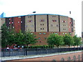
The Byker Wall
Hailed as a marvel of design, the Byker Wall was completed in 1976. Communities had their old homes demolished and were moved back into their new environment but they never recovered the community spirit they once had. The Byker Wall is now a listed building.
Image: © Christine Westerback
Taken: 13 Aug 2005
0.09 miles
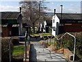
10
Millers Road
Leads onto Chillingham Road straddling the Metro Line.
Image: © MSX
Taken: 17 Jun 2006
0.09 miles